Route Editor

| Guide | ♦ | 20 Triplogs | 2 Topics |
details | drive | no permit | forecast | 🔥 route |
stats |
photos | triplogs | topics | location |
| 151 | 20 | 2 |
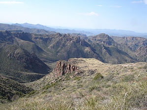
29 Electrons with No Charge Circling Camp by topohiker   Note NoteYou should only consider this hike if you can do the Grand Canyon rim to rim. This hike involves high miles (22 miles), elevation gain (5,850 feet), route-finding skills, and a couple of miles of bushwhacking. Access First thing, there has been some road damage on the FR to the Mormon Grove TH. There was a landslide that has covered about half the road and about 2 feet on the other side of the road has washed away down the drop-off. I have an unmodified Jeep. I was OK going up. It was a little dicey for a couple of seconds. I do not recommend any non-4x4 vehicles for this road until the forest service fixes it. You should be an experienced 4x4 driver to get past this section. The other parts of the road had some minor washouts and two creek crossings.
We (two Mikes and me) started hiking about 7:40 am on the Saddle Mountain trail (91). This is an old Jeep road that leads to the Story Mine. The trail was soggy. We came to the trail intersection of Saddle Mountain (91) and Sheep Creek (88). We turned down the Sheep creek and descended to McFarland Canyon as we passed the Thicket Trail (95) intersection. The creeks were flowing well, but they were still passable. We hit the Sheep Creek (88) and the Copper camp (87) intersection and took off on the Copper Camp trail. We would be returning on the back to this point via the Sheep Creek trail. Hike The trail starts to slowly climb out of the creek bed and becomes harder to follow. The trail eventually comes to an open area. You can see a big valley with Bartlet lake, Horse Shoe lake, and the Verde River in the background. This is one cool area. It is remote with spectacular 360 views of the area. The trail climbs up higher and then levels off for a bit. Now you descend at a very fast rate. The trail turns very faint and then disappears at times. There are 3 to 4-foot cairns to guide along the way. You just hike from cairn to cairn. If you get off-trail, just stop and look for the next cairn. It will be there. Now you go down to a creek bed. You'll pass an old fireplace (33 degrees 57.721'N , 111 degrees 34.132W) from some old house. Now the trail goes in and out a creek bed. Things get tricky now. The trail gets pretty hard to follow and the pricker bushes don't help you. If you take it slow and look hard for the cairns this section is doable. You'll pass an old fence post. You will need to eventually be on the left side of the creek, so look carefully for the creek crossing. The copper camp is at 33 degrees 58.083N , 111 degrees 35.151W. This is a good place for a light snack. I wouldn't recommend eating a big lunch yet, because you have to climb/bushwhack up the Cypress Ridge. Now you leave the trail and start the bushwhacking section of the hike. The biggest difference is that there are no more cairns to guide your way. I highly recommend downloading the GPS track for the hike and following it. You cross the creek and start hiking up the ridge. You go through two rock scrambles before you reach the top. We use the following waypoints to guide us up the mountain in this order: 33 degrees 58.219 N, 111 degrees 35.031 W 33 degrees 58.344 N, 111 degrees 34.484 W 33 degrees 58.466 N, 111 degrees 34.313 W 33 degrees 58.688 N, 111 degrees 34.178 W (this is top) There are two or three cairns along the way, but you don't see them until you pass them up. Once you're at the top, stop and study the terrain. Your target is 33 degrees 59.760 N, 111 degrees 32.996 W. This waypoint is straight ahead and a little to the right from where you're standing. From our previous experience, you're better off going to the meadow to your far left. You will move a lot faster in the meadow as appose to going through the brush, downfall, and the gullies. We went through the meadow, then we climbed down a hill. We then went to another meadow to the left. The meadows were wet. The groups' consensus was to take the path of least resistance and worry about hitting the waypoint when we get closer to the Sheep Creek trail. We left the second meadow and climbed a hill. I keep on an eye on my GPS the whole time watching where the waypoint was. On this hill, we could see the old corral with a concrete water box(this is our waypoint). We headed down to it. We were finally back on a "trail". In hindsight, we should have stayed in the meadow longer and avoided the climbing and descending of the last hill. This part of the sheep creek trail sees very little use. The trail is overgrown, but there are good cairns to guide you along. The trail has numerous creek crossings and some of them are tricky. We had two spots where the group had to spend 5/10 minutes looking for the trail. One section was so bad that we put up some cairns to help the next people through. Now the trail climbs and climbs. The trail levels off and we were glad, but that didn't last! The trail then climbs again. The payoff is awesome views of the valley below. The trail does eventually stops climbs and levels off. The trail is level for a little bit, then there's a steep climb down and we wind up at the Sheep Creek (88) / Copper Camp (87)intersection. This is where we start the loop section of the hike in the morning. By now it's dark so we break out the flashlights and return to the car the same way came out. We reach the car by 9 PM. I had packed 6 liters of fluids for the day and drank all of it. We had tried this hike three times and finished it twice. But wait the adventure is not over. Remember the landslide section of the road? When we got to it, the ruts were pretty deep. I got stuck in the ruts. The two Mikes got out, dug some of the clay, and built up the ruts to give me more clearance. With them pushing, I was able to get through this area. Check out the Official Route and Triplogs. Note This is a more difficult hike. It would be unwise to attempt this without prior experience hiking. Leave No Trace and +Add a Triplog after your hike to support this local community. | |||||||||||||||||||||||||||||||||||||||||||||||||||||||||||||||||||||||||||||||||||||||||||||||||||||||||||||||||||||||||||||||||||||||||||||||||||||||||||||||||||||||||||||||||||||||||||||||||||||||||||||||