Route Editor

| Guide | ♦ | 2 Triplogs | 0 Topics |
details | drive | no permit | forecast | route |
stats |
photos | triplogs | topics | location |
| 24 | 2 | 0 |
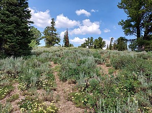
The biggest runt in the USA by DixieFlyer Bridger Peak (elevation of 9,255 feet and prominence of 855 feet) is in the Uinta-Wasatch-Cache National Forest in northeastern Utah. It is the highpoint of Rich County and it is less than 500 feet from the Utah-Idaho border. History Bridger Peak was an unnamed peak until 1999 when a Utah newspaper ran a contest to name the peak. The winning entry, Bridger Peak, was in honor of frontiersman Jim Bridger(1804-1881) who was an early explorer of this area.
Bridger Peak is Utah's runt peak. A runt peak is the lowest elevation county highpoint in a state. While Bridger Peak is a runt, it has the highest elevation of any runt peak in the United States. brrrrr About 11 miles from Bridger Peak is a unique geologic formation known as Peter Sinks. Peter Sinks is a natural sinkhole that is about 1/2 mile wide and is at an elevation of almost 8,200 feet. It has no natural outlet to drain water or air, which combined with high altitude and dry air often results in some frigid temperatures. According to the Utah State University Climate Center the second coldest temperature ever recorded in the continental US was at Peter Sinks: -69.3F on February 1, 1985. Hike The hike is about half on-trail and half off-trail. From the trailhead, the trail first descends a bit and then goes eastward up a very steep hillside. Unfortunately, there are no switchbacks to compensate for the steepness, so you might find yourself stopping a time or two to catch your breath. Once near the top of the hill, the trail levels off and heads to the south; take care not to travel too far on the trail at this point because it leads away from Bridger Peak. If you look uphill to your left you'll see a cliff band. You'll need to go off-trail to get over the cliff band, but don't worry -- there are ways through the cliff band that will keep the hike at class 1. Once past the cliff band, you will continue off-trail to the north. The grade is modest as you make your way through a forested area to the summit. While the trees are a bit thick, it is fairly easy to find lanes to hike through and avoid most of the vegetation. Just follow the path of least resistance and keep going uphill to the summit, which is marked by a fairly large cairn. Some trees at the summit prevent sweeping 360-degree views, but there is a nice view to the east of Bear Lake, and there are some nice views of the surrounding peaks to the south and to the west. If you are so inclined, you can hike north for less than 500 feet and cross over into Idaho. After spending some time at the summit, just reverse course to go back to the trailhead. Synopsis This relatively short hike has some nice views and will give you a decent workout, but it is mostly of interest to those looking to hike to a county highpoint. Check out the Official Route and Triplogs. Leave No Trace and +Add a Triplog after your hike to support this local community. | |||||||||||||||||||||||||||||||||||||||||||||||||||||||||||||||||||||||||||||||||||||