Route Editor

| Guide | ♦ | 20 Triplogs | 0 Topics |
details | drive | permit | forecast | route |
stats |
photos | triplogs | topics | location |
| 227 | 20 | 0 |
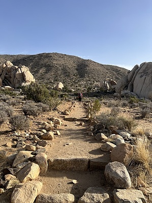
Not joshing, this is a forest by mt98dew Joshua Tree is currently 1 of 63 National Parks scattered across the US. These Parks are treasured resources showcasing and preserving the diverse and unique beauty found in our backyard. The Joshua Tree National Park is an 800,000-acre preserve located in eastern California, just off the I-10. This Park is known for its fantastical granite rock formations and, of course, for its “forest” of Joshua Trees. Joshua Tree National Park is one of the most vehicle accessible parks, allowing you to enjoy most of the park's wonders from your car. This Park has 3 paid entry points (Box Canyon Rd. and 2 others off of 29 Palms Rd.) that provide access to over 30 designated trails. There are over 200 miles of trails varying in length from under a mile to over 40 miles. The Ryan Mountain Trail is located in the western end of the Park and is immediately accessible from Park Blvd. The TH has parking for about 20 cars, has a bathroom, and a generic trail map of the area.
Ryan Mountain Trail takes off adjacent to the trail map heading in a southeastward direction. Both the destination and trail are very obvious. The mountain is directly in front of you, and the trail heads straight towards it. Initially, the path is lined with stones, and you have two cool rock monoliths framing the trail, but you quickly start your ascent up the mountain. The trail is characterized by stairs. Lots of stairs. This makes it incredibly easy to follow. Just follow the staircase. At 0.22 miles, there is a signed split in the trail. Continuing west past the split will start a gradual wrap around of what turns out to be a secondary peak of Ryan Mountain. There were a couple of noteworthy features during the climb. At 0.3,8 you come in sight of the “Oyster Bar”. A large granite monolith that takes up most of the slope on Ryan Mountain. And then around 0.98, the primary and secondary peaks of Ryan Mountain come together, forming a steep valley. You quickly reach the top and enter a basin surrounded by hills. The trail continues to climb steadily along the inner east primary slope. Around 1.1, the trail starts to angle east and becomes more gradual. At 1.2, you reach an eastern saddle that provides a great view toward the east. The hill layering is fantastic. At this point, you can see the end. Most of the climbing is over, and it is just a gradual ascent to the top. There are some nice views of Queen Valley to the west and Lost Horse Valley to the south, and distant views of San Jacinto and San Gorgonio to the southwest. There will actually be a few Joshua Trees to spice up your pictures. There are no connecting trails with Ryan Mountain, so return the way you came. Water Sources There is no water on site, so plan accordingly. Synopsis This is a great trail to do if you have the time. For most people, this is a one-day drive through the park with other, shorter trails available. Ryan Mountain is one of the more strenuous options and is at least a two-hour commitment. The trail is easy to follow and provides some of the best views of the Park. Check out the Official Route and Triplogs. Leave No Trace and +Add a Triplog after your hike to support this local community. | ||||||||||||||||||||||||||||||||||||||||||||||||||||||||||||||||||||||||||||||||||||||||||||||||||||||||||||||||||||||||||||||||||||||||||||||||||||||||||||||||||||||||||||