username
X
password
register
for free!
help
 This is likely a great time to hike this trail!  Check out "Preferred" months below, keep in mind this is an estimate.
  

Sabrina Basin Trail 31E01, CA

Guide 12 Triplogs  0 Topics
  4.7 of 5  
Fav
Wish
1
details
drive
permit
forecast
route  
stats
photos
triplogs
topics
location
114 12 0
Statistics
tap row or icons for details
Difficulty 4 of 5
Distance One Way 5.78 miles
Trailhead Elevation 9,475 feet
Elevation Gain 1,929 feet
Accumulated Gain 2,149 feet
Kokopelli Seeds 12.94
unreported if dogs are allowed
editedit > ops > dogs to adjust
feature photo
Photos Viewed All MineFollowing
Inaugural Calculation on Button Tap!
15  2024-10-08
Sabrina Basin Trail to Blue Lake
Oregon_Hiker
21  2022-07-02
Sabrina Basin Trail to Dingleberry Lake
Oregon_Hiker
16  2020-07-23
George Lake from Sabrina Trailhead
Oregon_Hiker
19  2020-07-21
Sabrina Basin Trail to Emerald Lakes
Oregon_Hiker
22  2018-09-14
Lake Sabrina Trail to Donkey Lake
Oregon_Hiker
26  2018-07-20 John9L
19  2016-09-11
Hungry Packer Moonlight & Midnight Lakes
trekkin_gecko
30  2016-09-11
Hungry Packer Moonlight & Midnight Lakes
Tortoise_Hiker
Page 1,  2
Author
author avatar Guides 16,843
Routes 17,472
Photos 24
Trips 1 map ( 6 miles )
Age 28 Male Gender
Location HAZ, TrailDEX
Associated Areas
list map done
Sierra Nevada Region
Historical Weather
Trailhead Forecast
Radar Map
Expand Map
Preferred Jul, Aug, Jun, Sep
Sun  5:28am - 6:17pm
Official Route & 2 Rts
 
6 Alternative


remove free decal offer

 Likely In-Season!
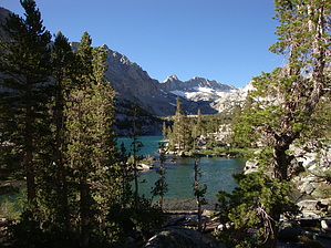
Climbing the hillside on the south side of Sabrina Lake, the trail leads to a series of high alpine lakes in a basin surrounded by glacier flanked 13,000 ft. granite peaks. Many day hikers enjoy visiting Blue Lake (2.5 miles). If hikers continue on the trail it will take them to Dingleberry, Hungry Packer, and Midnight Lakes. The side trail to Donkey and Baboon Lake is more rugged and is not recommended for stock. Beyond Blue Lake, bear canisters are the only practical way to store food due to the lack of tall trees.


2018-07-14 HAZ_Hikebot


    Check out the Official Route and Triplogs.

    Note
    This is a moderately difficult hike.
    Leave No Trace and +Add a Triplog after your hike to support this local community.

    One-Way Notice
    This hike is listed as One-Way.

    When hiking several trails on a single "hike", log it with a generic name that describes the hike. Then link the trails traveled, check out the example.
    WARNING! Hiking and outdoor related sports can be dangerous. Be responsible and prepare for the trip. Study the area you are entering and plan accordingly. Dress for the current and unexpected weather changes. Take plenty of water. Never go alone. Make an itinerary with your plan(s), route(s), destination(s) and expected return time. Give your itinerary to trusted family and/or friends.

     Permit $$
    no fees or permits reported

    if incorrect tell us about it


     Directions
    or
     Road


    To hike
    From Bishop go west on State Route 168 (Line Street) approximately 18 miles. After Aspendell, look for the overnight parking at the North Lake turnoff.

    Parking for this trail is at the intersection with North Lake Road
    page created by HAZ_Hikebot on Mar 10 2010 12:25 am
     90+° 8am - 6pm kills
    helpcorrectionissue

    end of page marker