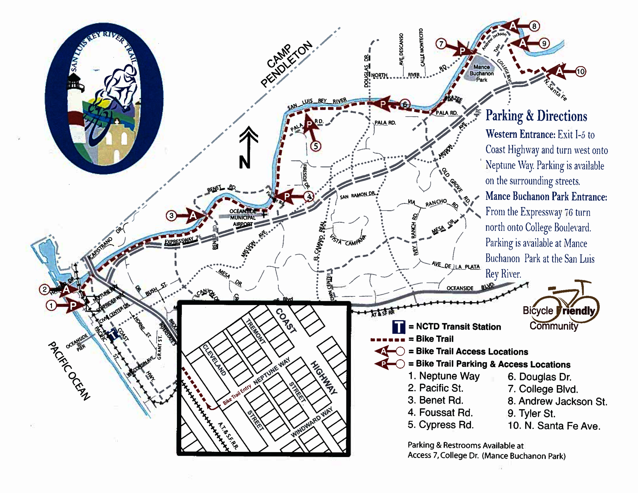
To hikeAccess 1 – Neptune Way
Amenities
Street Parking
Information Kiosk
Access 1 is the western-most entrance and marks the official start of the trail at the 0.0 mile marker. It is within a few blocks of the Oceanside Transit Center where commuters can board the Coaster, Amtrak and Metrolink trains or North County Transit District buses, all of which can accommodate bicycles. This access will eventually link with the Coastal Rail Trail that will run in a north-south direction connecting to Carlsbad and further into San Diego.
Access 2 – Pacific Street
Access 3 – Benet Road
Amenities
Information Kiosk
Access 3 lies just west of the Oceanside Municipal Airport. Access the Benet Road entrance off Highway 76. Head east on Highway 76 and turn left on Benet Road. There is no parking lot at this access point.
The Benet Road access is located at mile marker 2.4 on the trail.
Access 4 – Foussat Road
Amenities
Parking Lot
Information Kiosk
Access 4 lies northeast of the Oceanside Municipal Airport and can be accessed off Highway 76. Head east on Highway 76, turn left on Foussat Road, and follow the road to the trail access parking lot.
Located at mile marker 3.2 on the trail.
Access 5 – Cypress Road
Access 6 – Douglas Drive
Amenities
Information Kiosk
Picnic Tables
Trash Receptacles
Access 6 lies further north and inland at the 5.4 mile marker and may be reached by traveling east on Highway 76. Turn left on Douglas Drive and travel approximately 1 mile. The access and small parking lot is located on the left-hand side of Douglas Drive. Access to the parking lot is not available when traveling north. To safely access the lot and trail, travel to North River Road, turn around and head south. Turn right into the lot at the Douglas bridge overpass.
Access 7 – College Boulevard/Mance Buchanon Park
Amenities
Parking Lot
Information Kiosk
Picnic Tables
Trash Receptacles
Restrooms at Park
Access 7 is the easternmost access point for the trail.
Access 7 is at Mance Buchanon Park which offers a larger parking lot, a staging area, restrooms, water fountains, shaded picnic tables, shaded grass areas and an additional pathway that loops the park. The College Boulevard access can be reached by traveling east on Highway 76 to Douglas Drive. Turn left on Douglas Drive and travel approximately 1.2 miles. Turn right on North River Road traveling east to College Boulevard. Turn right on College; the trail access is immediately following your right turn.
The College Blvd. access marks the 7.2 mile marker. From College to North Santa Fe Avenue there is an additional 1.8 miles = 9 miles total.
Access 8 – Andrew Jackson Drive
Bike lane detours onto surface street for ¼ mile.
Access 9 – Tyler Street
Bike lane detours onto surface street for ¼ mile.
Access 10 – North Santa Fe Avenue/Highway 76
Amenities
Parking Lot
Information Kiosk
Trash Receptacles
Access 10 is the easternmost access point for the trail.
 Route Editor


