Route Editor

| Guide | ♦ | 2 Triplogs | 0 Topics |
details | drive | permit | forecast | route |
stats |
photos | triplogs | topics | location |
| 30 | 2 | 0 |
The other Boucher Trail by azbackpackr Arriving at the tiny ranger station at Palomar Mountain State Park, pay the per car per day fee ( $$ info in permit section ). A trail map is available for $2 ( as of 2013 ), which is somewhat helpful. The parking for this trail is just past the entrance station on the left, at the Silvercrest Picnic Area. From this parking area the views are outstanding!
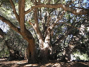
Arizonans will be familiar with another Boucher Trail, the one in Grand Canyon, which is pronounced "boo-shay," named after a Frenchman. But Palomar's Boucher is pronounced "Booker." According to volunteer fire lookout Ramon Thomas, it is actually a misspelling of the name of the family who owned the property a long time ago. Their name was Bougher. Don't ask me how it was pronounced! Walking uphill on this single track trail you'll pass many black oak trees, some with large round clumps of mistletoe attached to the branches. Mistletoe is a parasitic plant which depletes the energy of the host tree. As you approach the Boucher Fire Lookout and microwave structures you'll also see some white firs. The historic Boucher Fire Lookout is an old wooden tower. Sometimes on weekends it's open for a tour, if the volunteer is available. This tour ended up costing me about an hour, because the volunteer had so much interesting information to pass along. The view is spectacular. I could see the ocean with four islands, San Clemente and Santa Catalina off the California coast, and the Guadalupe Islands off Mexico. I could see big peaks, including San Jacinto and San Gorgonio, with snow on top. I could see the city of San Diego, and a very long stretch of coastline. The elevation at the tower is over 5,000 feet. When I was able to drag myself away, I still had most of the hiking loop to complete! Crossing the parking lot, I started down the hill, and quickly found the wooden gate to the continuation of the trail. The next mile or so takes the hiker through the 2007 burned area. Chaparral has grown up thickly and is kept trimmed back by the trail crew. It is a bit like walking between two pruned hedges! Towering above this tunnel are pines, firs, and black oaks, some burned, some recovering, some unscathed from the fire. When you reach Nate Harrison Road, cross over and pick up the trail again, with a new name, the Adams Trail. Follow it to the Cedar Grove Group Campground. Along the way you'll be walking through a thickly forested area with firs, oaks, and dogwood, until you come out into a meadow next to the campground. Keeping to the right hand side of the campground you will pass several enormous live oaks and also some of the tall cedar trees, whose bark somewhat resembles that of redwoods. Keep watching for a little sign that says "trail." Follow it, cross a small road, and start up the somewhat steep hill on the trail to Scott's Cabin. Eventually passing the remains of the cabin, turn right at the next junction, and eventually you will end up directly across the road from where you parked, at the Silvercrest Picnic Area. Gate Policy: If a gate is closed upon arrival, leave it closed after you go through. If it is open, leave it open. Leaving a closed gate open may put cattle in danger. Closing an open gate may cut them off from water. Please be respectful, leave gates as found. The exception is signage on the gate directing you otherwise. Check out the Official Route and Triplogs. Leave No Trace and +Add a Triplog after your hike to support this local community. | ||||||||||||||||||||||||||||||||||||||||||||||||||||||||||||||||||||||||||||||||||||||||||||