 Route Editor

| Guide | ♦ | 34 Triplogs | 0 Topics |
details | drive | no permit | forecast | 🔥 route |
stats |
photos | triplogs | topics | location |
| 455 | 34 | 0 |
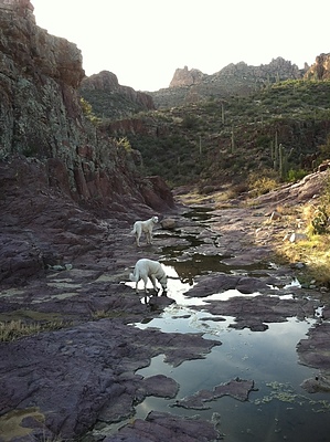
Meandering through Randolph by FOTG   Overview OverviewThis hike will take you off-trail down a scenic canyon in the central Superstitions to the confluences of Fraser and Randolph Canyons and the intersections of Red Tanks #107 and Coffee Flats Trail #108. Randolph Canyon provides excellent opportunities for loops and backpacking. However, this hike only covers the one-way off-trail route/section of Randolph Canyon from JF Trail #106 to Coffee Flats Trail. Warning This is undoubtedly a benign canyon and off-trail route. However, a certain level of route finding, map reading skills, and physical endurance is probably necessary to complete the hike. This should not deter anyone, as Randolph Canyon is relatively easy going for an off-trail hike in the Superstitions and amounts to some pretty standard boulder hopping and dry creek bed walking.
The most logical way to complete Randolph Canyon, in my opinion, is via Woodbury Trail Head. From Woodbury TH, follow the JF Trail north. After a short walk, you will pass the wilderness boundary sign. The large mountain to the northwest in the far distance is the distinct La Barge Mountain. You will cross two washes before reaching the intersection of JF Trail and the upper sections of Randolph Canyon. This is where you will leave the trail and head down the canyon. Some maps may show a few informal trails through Randolph Canyon. However, there is no established route, and walking down the creek bed seems to be the best option. One may find a few old cattle and ranching trails in some of the lower benches, complete with cairns. However, these trails generally dead-end quickly or become a cat-claw nightmare in a hurry. I found it best to stick to the creek bed. Your first major landmark is the fence that crosses the creek. It is still in great shape and not easy to go under or over, so your best bet is to take the marked side trail leading around it. The trail will lead to a relatively new cattle trough, although I do not think it can be counted on as a reliable water source along this route. If one takes a closer look around, they might notice indicators of prehistoric settlement, remember rules and etiquette surrounding these sites. From here, the hike is a pretty standard creek bed hike with minor obstacles to navigate, some boulder hopping, and almost little bushwhacking. Your next major frame of reference will be the concrete dam built into Randolph Canyon's bedrock, near the Randolph Spring area. The dam was holding a significant amount of water during my trip. However, I can't speak for the reliability of water during the dry months here. There are some larger willow trees in the area, and the shady spot would make an ideal point for taking a quick break or having lunch. The spring area marks nearly the half-way point of this hike, and the hike continues in much the same fashion until you start to near the junction of the Red Tanks and Coffee Flats trails, near Dripping Springs. I would suggest skipping your first opportunity to link up with the Red Tanks Trail and continue down the flat bedrock of Randolph Canyon south towards Dripping Springs. This area is very picturesque and is probably one of the nicer stretches of Randolph Canyon. After the flat bedrock area, one will find themselves near the confluence of Fraser and Randolph Canyon, and this is where this hike ends. One has a couple of options from here, turning around and retracing the route for about an 8-9 mile day, or simply taking the natural loop back utilizing Coffee Flats Trail back to Woodbury TH, for about a 9.5-mile day. Final Points to Consider Although Randolph Canyon is an exclusively off-trail hike, this should not deter anyone as it's a pretty straightforward canyon to navigate, with most of the guesswork eliminated by choosing to hike down the canyon rather than up. Randolph Canyon offers an excellent opportunity for a beginner hiker to get their off-trail feet wet, without much bloodshed, and a lack of real difficult areas to get turned around. Check out the Official Route and Triplogs. Leave No Trace and +Add a Triplog after your hike to support this local community. One-Way Notice This hike is listed as One-Way. When hiking several trails on a single "hike", log it with a generic name that describes the hike. Then link the trails traveled, check out the example. | ||||||||||||||||||||||||||||||||||||||||||||||||||||||||||||||||||||||||||||||||||||||||||||||||||||||||||||||||||||||||||||||||||||||||||||||||||||||||||||||||||||||||||||||||||||||||||||||||||||||||||||


