Route Editor

| Guide | ♦ | 4 Triplogs | 0 Topics |
details | drive | no permit | forecast | route |
stats |
photos | triplogs | topics | location |
| 52 | 4 | 0 |
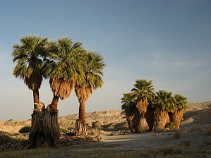
Desert Solitude by Jim This is not so much a hike, as a place to visit, sit, relax and be alone while taking in the sights, sounds, and smells of the desert. In winter and early Spring, there will probably be others nearby or in and out, but once the heat builds in, solitude should be the rule. My advice is to budget at least 2 hours to relax and enjoy the area, but a quick in and out does work, too. I also suggest evening, arriving 90 minutes before sunset, to enjoy the oasis in a pleasant light and as the desert cools off. The smell of the cooling desert soils on a day near 100 is really interesting.
Access is the only real challenge, and you will need high clearance. There is loose sand and gravel, so while you might try to do this without AWD or 4WD, don't blame me if you get stuck. I also suggest a map, even the crude free one from the visitor center, to give an indication of the roads out here. A short distance up the main Arroyo Salado will bring you to another right turn. It is about 500 feet up the wash, and it takes you out of the sand and gravel up on to the badlands sediments. Take this 2 track west for maybe 1/4 of a mile, and you can clearly see Five Palms Oasis above the desert hills. This is an interesting visit, as well. Check out the Official Route and Triplogs. Leave No Trace and +Add a Triplog after your hike to support this local community. | ||||||||||||||||||||||||||||||||||||||||||||||||||||||||||||||||||||||||||||||||||