username
X
password
register
for free!
help
 This is likely a great time to hike this trail!  Check out "Preferred" months below, keep in mind this is an estimate.
   🔥

Sherwin Lakes, CA

Guide 6 Triplogs  0 Topics
  5 of 5  
Fav
Wish
0
details
drive
permit
forecast
🔥
route  
stats
photos
triplogs
topics
location
57 6 0
Statistics
tap row or icons for details
Difficulty 3 of 5
Route Finding 2 of 5
Distance Round Trip 5.6 miles
Trailhead Elevation 7,838 feet
Elevation Gain 836 feet
Avg Time Round Trip 4 hours
Kokopelli Seeds 9.78
 Backpack Yes
unreported if dogs are allowed
editedit > ops > dogs to adjust
feature photo
Photos Viewed All MineFollowing
8  2016-04-02 slegal
5  2015-01-25 slegal
15  2014-01-02 slegal
13  2011-12-26 slegal
6  2008-08-03 slegal
10  2007-07-06 slegal
Author
author avatar Guides 77
Routes 106
Photos 2,987
Trips 57 map ( 363 miles )
Age 63 Male Gender
Location Thousand Oaks, CA
Associated Areas
list map done
Sierra Nevada Region
Historical Weather
Trailhead Forecast
Radar Map
Expand Map
Preferred Jun, Sep, May, Oct → Early
Seasons   Late Spring to Early Autumn
Sun  5:28am - 6:21pm
Official Route & 3 Rts
 
1 Alternative
 
Historic Fire Perimeteracres
🔥 2020 Creek Fire834


 Likely In-Season!
The Sherwin Lakes are located on the north side of the Sherwin Ridge. The location of the lakes can be easily seen from the town of Mammoth Lakes. The lakes are higher than the town, so you can't see the lakes from town.


The trailhead starts out in chaparral and the base of the mountain. After a short walk from the parking area the trail crosses a bridge over Sherwin Creek and enters a pine forest. From this point on it's almost all uphill.
remove free decal offer
Much of the trail is under trees. However, about half way up the trail the trail loses the forest and heads through an open slope of Manzanita. The Manzanita is some of the taller Manzanita for the Mammoth Lakes area, but is still only about waste high. On warm summer days this lengthy exposure to the sun is not overly welcome. Fortunately, the trail gets back into the forest again until the trail flattens out and reaches a long straight section.

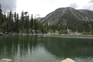
The long straight section is in a grooved channel in the knoll that it is located. It almost seems manmade, but there are no roads here and there is no evidence of mining activity in the immediate area, so I don't think is it manmade. Just east of the Sherwin Lakes there are a couple of large glacial moraines, and this doesn't look anything like those moraines, so I don't think it's a moraine either. I guess I just have to be satisfied with not being able to explain it.

Soon the trail begins to climb again and wraps around a small hill for the final approach to the largest of the Sherwin Lakes. While wrapping around the hill the trail passes two smaller lakes, but these lakes are not on the trail and are not visible from the trail. The largest of the Sherwin Lakes is right next to the trail. If you pass the lake there is a well worn path that heads due south along the eastern edge to the lake and heads straight toward the second large lake behind the one along the main trail.

The real gem in this bunch is above the back lake. There is a beautiful small lake that requires a short scramble up alongside a small waterfall. The lake is turning into a meadow as it fills with sediment. However, the benefit of this silting of the lake is that the surface water is usually quite smooth and reflective, even on windy days.

If you head back to the main trail and continue on to the southeast, the trail will take you to Valentine Lake. This is a considerably longer and more strenuous hike. But that is for a different hike description. Enjoy!

2011-03-12 slegal


    Check out the Official Route and Triplogs.
    Leave No Trace and +Add a Triplog after your hike to support this local community.
    WARNING! Hiking and outdoor related sports can be dangerous. Be responsible and prepare for the trip. Study the area you are entering and plan accordingly. Dress for the current and unexpected weather changes. Take plenty of water. Never go alone. Make an itinerary with your plan(s), route(s), destination(s) and expected return time. Give your itinerary to trusted family and/or friends.

     Permit $$
    None


     Directions
    or
     Road
    FR / Dirt Road / Gravel - Car Okay

    To hike
    From Mammoth Lakes take Old Mammoth Road south to Sherwin Creek Road and turn left. Sherwin Creek Road is a dirt road. After about 1.4 miles on Sherwin Creek Road turn right onto a smaller dirt road. There will be a sign advising that the right turn will take you to the Sherwin Lakes trailhead. Another sign will tell you to turn left onto another dirt road which will quickly dead end into the parking area for the trailhead.
    page created by slegal on Mar 12 2011 12:38 am
     90+° 8am - 6pm kills
    helpcorrectionissue

    end of page marker