Route Editor

| Guide | ♦ | 7 Triplogs | 2 Topics |
details | drive | no permit | forecast | 🔥 route |
stats |
photos | triplogs | topics | location |
| 153 | 7 | 2 |
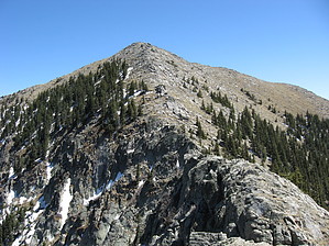
Monarch of Southern New Mexico by Jim The hike begins from the "Scenic" trailhead, just outside of Ski Apache. You start on trail # 15, and take this up a couple of switchbacks and a nice grassy slope to an intersection with trail # 25, the Crest Trail. The sign is currently falling apart at this junction, but further on a small sign with, "Trail # 25", makes this clear.
The trail crosses a small creek, or creek bed, and begins to ascend some switchbacks passing through the burned forest. Soon, you round a bend and end up opposite the ski slopes and on a grassy hillside. This takes you to a junction with another trail. Ignore this side trail, and descend slightly to Ice Springs, coming directly out of the hillside. From here you will climb up through intact spruce to the ridge leading up to the top of the resort's new gondola lift. The area of dense forest holds snow well into spring, even in dry years. Once on the ridge, there is another trail junction sign. Simply turn left, or south, and towards the higher ground and you'll be heading in the right direction. Once at the gondola lift, you can either go directly to the saddle on a graded dirt path, or to the top of Lookout Mountain. If you go to Lookout, you can add in extra elevation. Either way, you cross the saddle and ascend the steep north slope of Sierra Blanca. There are a few social trails, but it is still off trail hiking. Near the top it is very steep, and class 2 at times, but as long as not ice covered or very windy, it should be fine. Enjoy the green, grassy summit, sign in at the mailbox, and descend the way you came. You will very likely be alone on top. One interesting note, is the appearance of the mountain from different aspects. The west and south have huge rocky and grassy ridges leading to the summit, creating the illusion of a much higher peak. The north and northeast views have trees almost right to the top, letting you know you are not on some 4,000 meter mountain. I believe this is the result of wind. In theory this hike is illegal, but there is no shortage of names in the summit register. It is obvious that many people head up here every summer. The summit is on the Mescalero Apache Reservation and while there were no signs or anything in the area indicating it is a closed mountain, internet rumors exist saying it is. The Ski area, owned and operated by the Apache Tribe, is on USFS land. Funny how that works out. Lookout Mountain makes for a nice, but substantially less than summit, should you find yourself unable to reach Sierra Blanca. I had no issues either of the times I hiked Sierra Blanca. From what I have read, permits are not given for Sierra Blanca by the Apaches. Check out the Official Route and Triplogs. Leave No Trace and +Add a Triplog after your hike to support this local community. | ||||||||||||||||||||||||||||||||||||||||||||||||||||||||||||||||||||||||||||||||||||||||||||||||||||||