Route Editor

| Guide | ♦ | 1 Triplog | 0 Topics |
details | drive | no permit | forecast | route |
stats |
photos | triplog | topics | location |
| 13 | 1 | 0 |
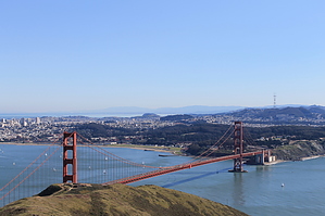
Golden Gate Views by JimmyLyding The hike starts at the developed trailhead (vault toilet!) by heading northeast on the Coastal Trail. The Coastal Trail also heads northwest from the trailhead, and you'll hit that portion later. Hike about 100 yards from the trailhead, cross McCullough Road and continue along the Coastal Trail for 0.2 mile to the turnoff to Slacker Hill. Go right and up Slacker Hill for another 0.2 mile to the top. The top has great views of the Golden Gate Bridge and central portion of San Francisco Bay. Clear days give million dollar views, but it is most assuredly windy most of the time.
There's some construction going on near the bottom of Rodeo Valley Trail including a new bridge (not open when I did this on March 3, 2012) and the beginnings of what looks to be a building. Possibly a new visitors center for Golden Gate National Recreation Area? Cross Bunker Road and take the spur trail on the south side of a large meadow to return to the Coastal Trail. This area used to have a lot of military installations, and the meadow looks like it could have been a rifle target practice range. You rejoin the Coastal Trail after 0.3 mile, and it's a 1.2 mile jaunt back to the trailhead with only 400' of AEG. Check out the Official Route and Triplog. Leave No Trace and +Add a Triplog after your hike to support this local community. | |||||||||||||||||||||||||||||||||||||||||||||||||||||||||||||||||||||||||||||||||||||