 Route Editor

| Guide | ♦ | 4 Triplogs | 0 Topics |
details | drive | no permit | forecast | map |
stats |
photos | triplogs | topics | location |
| 59 | 4 | 0 |
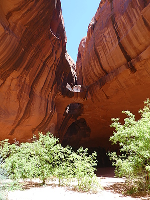
enjoy as a backpacking adventure by Steph_and_Blake  We were told that these arches are the most photographed of all those in Grand Staircase Escalante National Monument. Given the many beautiful and awe-inspiring formations in the Monument, these would really have to be something to behold. Note There is not a maintained trail for this hike. You must have a good map and equally good map-reading and route-finding skills. We saw only 2 other groups during the hike, so you can't rely on bumping into more knowledgeable hikers for guidance.
The traditional approach from Egypt trailhead (off Hole in the Rock Road, southwest of Escalante) is to drop into Fence Canyon and take it to its junction with the Escalante River. From there you head down river and make 5 crossings to reach Neon Canyon coming in from the east (left). To save time and eliminate 4 of the crossings, you can instead go overland and make a beeline for the river bank directly across from Neon Canyon. Given the rain and snow that the area had experienced in the past few days, we chose to go for the "fewer crossings" option. Regardless of the approach you decide on, you’re immediately faced with the challenge of getting yourself off the rim and down the somewhat steep slickrock. Take a moment to look for a path that seems do-able to you. But, before that, take some time to consult your map and memorize the landmarks that will guide you to Neon Canyon. Having done so, carefully zig-zag your way down to the flat(ish) area. Once down, turn around and imprint on your mind the image of where you started. At this point your goal is to stay on slickrock as much as possible as the intermittent sand is deep and soft. At the same time, try to keep from unnecessarily ascending/descending too much. There's still a lot of ground to cover and another steep slope to go down so avoid wasting precious energy. Eventually, after your eastward traverse of the plateau, you'll come to another rim. Your goal at this point is to find a way off the rim and down to the river. You'll see several paths to choose from, with one going down steep slickrock, another down a crack in the sandstone, and others to the south with a more gentle descent. Pick the one that's right for you. As you enjoy the soft, forgiving sand that helps to speed your way down try not to think about the sandy slog you'll endure on the way back. Upon reaching the river bed pick up one of a few trails all leading to the same river crossing that will deliver you to the Neon Canyon. If you don't have hiking sticks, grab a sturdy dead cottonwood branch to help you keep your balance in the water. After crossing the river, continue east up-canyon to a very obvious dead-end. Here you'll find a large pool of water, hanging gardens, and three arches cut into the sandstone by countless gallons of water. Drop a stone into the pool and take pleasure in the ripples reflected on the walls. Rest a bit, hydrate yourself and fuel up, for you'll need the energy (both physical and mental) for the long and steep trek back to the starting point. Like us, as you hike out, you might think this hike would probably be better enjoyed as a backpacking adventure. Check out the Triplogs. Note This is a moderately difficult hike. Leave No Trace and +Add a Triplog after your hike to support this local community. One-Way Notice This hike is listed as One-Way. When hiking several trails on a single "hike", log it with a generic name that describes the hike. Then link the trails traveled, check out the example. | ||||||||||||||||||||||||||||||||||||||||||||||||||||||||||||||||||||||||||||||||


