Route Editor

| Guide | ♦ | 3 Triplogs | 0 Topics |
details | drive | permit | forecast | route |
stats |
photos | triplogs | topics | location |
| 124 | 3 | 0 |
Peaceful Tsankawi by slegal The trailhead is located on the east side of Highway 4, just south of Highway 502 at N35 51.600 W106 13.474. A word of caution, you must have a permit to park your car here. There is a self service kiosk a few yards in from the trailhead where you can purchase a permit. If you visited the main part of Bandelier, leave your entrance pass on your dashboard so that the park service can see it. The park service patrols the area frequently. If you don't have the permit you will be ticketed.
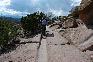
When you reach the top of the mesa you are standing in the middle of an ancient village. At a glance it may not look like much. However, look around and you will likely see broken pieces of pottery, evidence of stones organized by human and near the far end of the mesa are a couple of upright stones against a juniper that were laid out to catch and retain rain water runoff. At the far end of the mesa you will reach a ladder. The ladder takes you down to cliff dwellings. These are some pretty amazing dwellings. It is clear that the area was settled for an extended period of time as evidenced by the well worn steps in the rocks. Here you will see petroglyphs, multi room cliff dwellings and storage rooms, pieces of broken pottery, painted walls and cave ceilings blackened by the soot of fires. After visiting this section you'll have to climb the steps worn into the cliff wall to get back up to the main trail back to Highway 4. For a while, the trail is similar to the trail to the mesa top, a well worn channel in the rock. Then the trail becomes the familiar flat ledge as you approach the intersection of the loop. Then it is just a straight shot back to Highway 4.
Check out the Official Route and Triplogs. Leave No Trace and +Add a Triplog after your hike to support this local community. | |||||||||||||||||||||||||||||||||||||||||||||||||||||||||||||||||||||||||||||||||||||