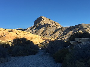
Starting from the Sandstone Quarry parking lot, head north on Turtlehead Peak trail. The trail generally heads north and is signed for the first mile or so, steadily gaining elevation. Turtlehead Peak is easily visible just ahead of you.
After about a mile, the trail starts to get steeper and the signs are replaced by green dots spray painted on the rocks. Turtlehead Peak is now to your right, and you are heading toward the saddle to the left of the peak.
From about a mile in and up to the saddle seemed like the most difficult part of the trail. You can continue scrambling up the rocks directly to the saddle, or you can follow some switchbacks slightly to your left. Either option takes you to the saddle, and then follow the trail toward the peak. After the saddle, the trail turns into several different trails all leading to the high point. None of the trails seem more "correct" than any other--staying to the west side is slightly more direct, taking some of the trails to the east seemed a little smoother.
The high point is easy to spot and is cairned. Retrace your steps back down. Watch your footing below the saddle, there are some loose spots.
WARNING! Hiking and outdoor related sports can be dangerous. Be responsible and prepare for the trip. Study the area you are entering and plan accordingly. Dress for the current and unexpected weather changes. Take plenty of water. Never go alone. Make an itinerary with your plan(s), route(s), destination(s) and expected return time. Give your itinerary to trusted family and/or friends.
To hike From Las Vegas, take Charleston Blvd west to Red Rocks Scenic Loop. Entrance fee is $7.00. Take the scenic loop drive to the Sandstone Quarry parking lot.
page created by HAZ_Hikebot on Feb 17 2016 6:18 pm
 Route Editor