Route Editor

| Guide | ♦ | 6 Triplogs | 0 Topics |
details | drive | permit | forecast | route |
stats |
photos | triplogs | topics | location |
| 76 | 6 | 0 |
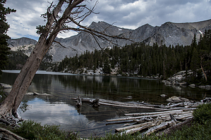
Best Lake in the Mammoth Lakes Area by slegal All of the hiking books that I have that cover the hike place the start at the Sherwin Lakes Trailhead. The other route starts at the Valentine Lake Trailhead. I started at the Valentine Lake Trailhead and the hike measured 8.44 miles from start to finish. I pieced together one of my Sherwin Lakes tracks with my Valentine Lake track and came up with a minimum round trip mileage of 10.2 miles.
The Valentine Lake Trailhead starts at an elevation of just under 7,500 feet. The first quarter mile is a gentle 8- vertical foot climb. The next 1.25 miles adds another 1,100 vertical feet. By the time you reach the junction with the Sherwin Lakes Trail you’ve logged 2.2 miles and almost 1,300 vertical feet of climbing. By comparison, If you take the Sherwin Lake trail, by the time you reach the junction with the Valentine Lake Trail, you’ve logged 3 miles and just 950 vertical feet. Since all of the hiking books cover the Sherwin route, I’ll spend the rest of this description covering the Valentine route. The trail heads up a steep set of switchbacks shortly after leaving the trailhead. There isn’t a lot of tree cover so warm days will be hard on you during this section. The trail is very loose pumice, which adds to the difficulty. Along the way the trail crosses through the eastern burn area of the Sherwin Lakes Fire of 2008. The unfortunate byproduct of this fire is that what little tree cover there was in this section has burned down. After a mile and a half of strenuous climbing, the trail starts flatting out a bit and continues this way until after you pass the Sherwin Lakes Trail Junction and the John Muir Wilderness boundary. A little less than a half mile past the wilderness boundary the trail enters an aspen forest. The vegetation is tight and gives the feel of walking through maze with three creek crossings included. Shortly after you exit the aspen forest you’ll reach a bubbling spring. Then not too long after that you’ll reach an unnamed lake and meadow. I mistakenly thought that this lake was Lost Lake, but after reviewing my topo map I realized that this lake was a different lake. It’s a pretty lake but not worth the hike if this is all you get out of it. We’re less than a mile from Valentine Lake. From the unnamed lake to Valentine Lake, the climb is tough. The trail rises just about 400 vertical feet in just seven-tenths of mile. The trail has lots of rock steps making for a more difficult climb. Just when you start hoping for some relief the trail flattens out and you’re just steps away from Valentine Lake. The first sight of the lake is spectacular. Take some time to enjoy the lake and recharge. While the second half of the hike is almost all downhill, it’s still tough and long. One of the things that I really like about this hike is that the trail is not busy. Even if you opt for the longer Sherwin Lakes Trail route, once you pass the Sherwin Lakes there won’t be many people on the trail with you. This provides a lot of solitude. Check out the Official Route and Triplogs. Note This is a moderately difficult hike. Leave No Trace and +Add a Triplog after your hike to support this local community. | |||||||||||||||||||||||||||||||||||||||||||||||||||||||||||||||||||||||||||||||||||||||||||||