Route Editor

| Guide | ♦ | 16 Triplogs | 0 Topics |
details | drive | permit | forecast | route |
stats |
photos | triplogs | topics | location |
| 122 | 16 | 0 |
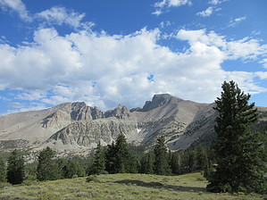
Top of the Snake Range by rally_toad This hike will take you to the top of Great Basin National Park, the top of the Snake Range, and the 2nd highest peak in Nevada. Many Nevadans consider Wheeler Peak to be Nevada's real highpoint, as much of the ridge of Boundary Peak (which is 60-70 feet taller than Wheeler) is in California. Begin the trail from the Wheeler Peak Summit Trailhead, though this makes the hike longer than if you started from the Bristlecone-Glacier trailhead, there is a bit less climbing if you start from the summit trailhead. Besides, the first mile of trail from the summit trailhead is exceptionally beautiful.
Begin on the Summit Trail from the trailhead, and you will be passing through some beautiful stands of aspen. The first mile of the trail is reasonably flat and easy. Walk it fast so you can get your blood flowing for the climb ahead of you. Before you know it, you've hit your first junction with the Alpine Lakes loop. About a tenth of a mile away is Stella Lake, definitely worth the 3-5 minute roundtrip walk from the intersection. The summit trail veers right and starts climbing. It seems as though this part of the trail is one long switchback. You will climb, and then the trail turns left sharply and takes you to the Wheeler Peak-Bald Mountain ridge. Before you know it, you are directly above Stella Lake and approaching tree line. Take your time and admire the alpine scenery. You are likely to find Krumholz in this area (low growing pine trees stunted by wind). Continue your climb towards Wheeler, which at this point still looks daunting. You will be above the tree line before too long and will only be seeing low growing plants and mosses. From time to time, you will come to small structures that you can use as a windbreak if you are unfortunate enough to be climbing on a cold, windy day. The first surveyors of the area created these structures, or so I'm told. Wheeler Peak was used by early surveyors as a triangulation point to find the elevation of nearby peaks. You know you are getting close to the top when you reach the never-ending switchbacks. At this point, many people are huffing and puffing from the thin alpine air. Keep going! You're almost there! When you are just about to give up and turn around, you will come to the sudden summit of Wheeler Peak, 13,063 feet above sea level. If it's a clear day, enjoy views of the Snake Range and Spring, Snake Valleys, and those of the surrounding mountain ranges. From the summit, you get a real grasp of the Great Basin, ranges and valleys stretch out as far as the eye can see. Sign the summit register, and enjoy the views and your accomplishment. When you are ready, head down the way you came. Make sure to notify rangers if you see any notable wildlife like bighorn sheep or mountain lions. Visitor sightings statistics can provide scientists and resource managers with valuable information since they can't be everywhere at once. Check out the Official Route and Triplogs. Note This is a more difficult hike. It would be unwise to attempt this without prior experience hiking. Leave No Trace and +Add a Triplog after your hike to support this local community. | |||||||||||||||||||||||||||||||||||||||||||||||||||||||||||||||||||||||||||||||||||||