Route Editor

| Guide | ♦ | 11 Triplogs | 0 Topics |
details | drive | no permit | forecast | 🔥 route |
stats |
photos | triplogs | topics | location |
| 98 | 11 | 0 |
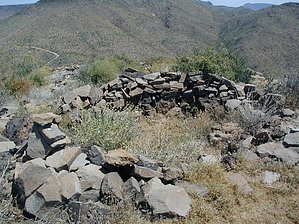
 Overview: As described in Dave Wilson's "Hiking Ruins Seldom Seen". There is no trailhead, the ruins are at the top of the rocky hill on the right of the trail. There is no trail, just bushwack for 0.5miles along the east (left) side of the barbed wire fence. Some rock scrambling is necessary to get to the top, probably easiest on the South side, but possible from the North too. Overview: As described in Dave Wilson's "Hiking Ruins Seldom Seen". There is no trailhead, the ruins are at the top of the rocky hill on the right of the trail. There is no trail, just bushwack for 0.5miles along the east (left) side of the barbed wire fence. Some rock scrambling is necessary to get to the top, probably easiest on the South side, but possible from the North too.Check out the Official Route and Triplogs. Leave No Trace and +Add a Triplog after your hike to support this local community. | |||||||||||||||||||||||||||||||||||||||||||||||||||||||||||||||||||||||||||||||||||||||