Route Editor

| Guide | ♦ | 14 Triplogs | 2 Topics |
details | drive | no permit | forecast | route |
stats |
photos | triplogs | topics | location |
| 137 | 14 | 2 |
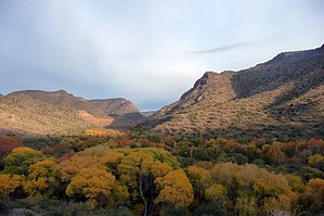
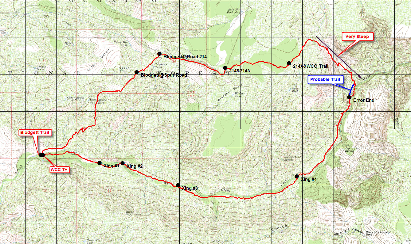
A challenging & scenic loop!! by gpsjoe   This hike is described in a Falcon Guide: "Hiking Arizona," Bruce Grubbs & Stuart Aitchison on page 138. I did it starting from the trailhead at the end of Bull Pen Road (FR215), which is better, in my opinion, than beginning from the Blodgett Basin Trailhead on FR214. Going up the Blodgett Basin trail in the morning and following FR 214 and FR214A takes out about 2,200 feet of the 3,000 feet of climbing that gets done on this loop. Also, there are no wet creek crossings until 9 miles into this 14-mile loop. I stayed dry until the last 5 miles, where you do four wet creek crossings but end up back at your car after that. This hike is described in a Falcon Guide: "Hiking Arizona," Bruce Grubbs & Stuart Aitchison on page 138. I did it starting from the trailhead at the end of Bull Pen Road (FR215), which is better, in my opinion, than beginning from the Blodgett Basin Trailhead on FR214. Going up the Blodgett Basin trail in the morning and following FR 214 and FR214A takes out about 2,200 feet of the 3,000 feet of climbing that gets done on this loop. Also, there are no wet creek crossings until 9 miles into this 14-mile loop. I stayed dry until the last 5 miles, where you do four wet creek crossings but end up back at your car after that.This hike has both easy and challenging parts. Not much signage along the way, and trail finding skills are required in some parts. After reaching the West Clear Creek trailhead on FR214A, the hike down the canyon there is very steep. One misstep is all that is needed for us to make the 6 o'clock evening news in Phoenix. For these reasons, I would only recommend this loop for physically fit, sure-footed experienced hikers looking for a bit of a challenge. I gave this a level 4 difficulty rating even though substantial parts of the hike are easy.
This was a total of 2.9 miles of an easy hike on a dirt road that reached a high elevation of just under 5,800 feet (the low point was at 3,600 feet at the start of the hike). The views of the terrain down toward WCC were good, but the best was yet to come. The hike on the WCC trail from the top was relatively flat for more than a half-mile and then became very steep after that. Frankly, it was a little intimidating, but the views were stunning here. I was glad to have two extra legs with me (my hiking poles) while I slowly made my way down this trail heading towards WCC. As I approached the bottom, I got off trail there for about 1/4th mile as I proceeded to a cairn actually at creek level. There I met the only other person I saw on the hike was gathering bait for some fishing he planned on doing. Fortunately for me, this guy was a local who claimed to hike/run the loop I was doing three times a week when he was younger. He told me I was off-trail, and the trail was above my current position. I then hiked the creek bed for a short distance, climbed up, and quickly found the trail. No more off-trail after that. At the creek, I had hiked 7.3 miles, and there were almost seven more miles to go to get back the TH and my car. After a little over 9 miles, I arrived at the first of 4 wet crossings of the WCC. I was using worn-out boots just for these crossings, so I did all of the crossings without delay. Hiking the last 7 miles along the WCC creek was easy to moderate and very scenic, with several rolling hills to climb along the way. There was some trail finding to do after a couple of the crossings since the continuing trail was not totally obvious or well marked. But that was a lot of fun for me. As I said at the start, I would recommend this hike for strong, experienced hikers seeking a challenging and scenic hike. I will do it again in the future sometime.
Check out the Official Route and Triplogs. Note This is a moderately difficult hike. Leave No Trace and +Add a Triplog after your hike to support this local community. | ||||||||||||||||||||||||||||||||||||||||||||||||||||||||||||||||||||||||||||||||||||||||||||||||||||||||||||||||||||||||||||||||||||||||||||||||||||||||||||||||||||||||||||||||||||