Route Editor

| Guide | ♦ | 7 Triplogs | 0 Topics |
details | drive | no permit | forecast | map |
stats |
photos | triplogs | topics | location |
| 16 | 7 | 0 |
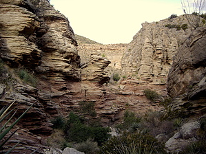
Canyons are inherently risky. Flash floods occur without notice on sunny days. Technical skills & surrounding topography knowledge required yet does not eliminate risk.
They're There...Really! by imike Between those main drainages lies two additional canyons: the Middle Cuts. The southern most of these is a rambling, boulder choked drainage that takes off from the main Southern Canyon cut just before the "Narrows", about a mile in from the main canyon mouth. This drainages travels up into the 6800' range before it basins out, getting a bit overgrown in that last section.
You upper basin terminates around the 6400' level, running into the ridge line of the southern Middle Cut, and the ridgeline route for the new Hershberger Peak trail. This is a great getaway hidden canyon... not that any of the drainages really see any use, but if you catch a busy weekend and need to have some private time, check out this short hike. The southern Middle Cut is 2.5 miles long from the canyon mouth. The northern Middle Cut is 1.8 miles long from the canyon mouth. Check out the Triplogs. Leave No Trace and +Add a Triplog after your canyon trip to support this local community. | ||||||||||||||||||||||||||||||||||||||||||||||||||||||||||||||||||||||||||||||||||||||||||||||