Route Editor

| Guide | ♦ | 33 Triplogs | 0 Topics |
details | drive | no permit | forecast | route |
stats |
photos | triplogs | topics | location |
| 232 | 33 | 0 |
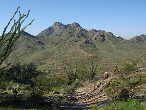
St Paddy's Mystery Loop by MEWhiteman  Overview OverviewThis is a pleasant loop hike in the northern end of the Phoenix Mountain Preserve. It includes several unnamed trails and parts of the Christiansen, Perl Charles, and Irregular Link trails. There are numerous unnamed trails in this area, and the hike frequently turns, so utilizing my GPS track is necessary as I have not noted every turn in my description. Hike Begin at the 40th Street Trailhead on the north side of the preserve. Hike west on an unnamed trail along the north border of the Preserve (avoiding trail #8 to the left) until just before the 32nd Street access. Then turn left at N33 34.083 W112 00.184. Take the right of the two trails to skirt around the hill on your right. Following my track, begin a short climb. After a left turn, the trail begins a longer climb to a saddle located at N33 33.746 W112 00.474 after passing through a small, pleasant valley. At the saddle, short trails climb to the tops of the hills on either side for lovely views. Back at the saddle, hike down the other side. Turn right at N33 33.645 W112 00.562 and continue following my track. You eventually end up at trail #100. Shortly bear right off #100 to begin a climb up to and then on the Irregular Link #1C to its intersection with trails 1A and 302. Turn left climbing switchbacks to the saddle and down the other side. Stay on 1A past junctions with the VOA trail and trails #302 and #304. Go straight when the 1A bears left. Following my track on various unnamed trails and trail #100 will bring you back to the 40th Street Trailhead. Check out the Official Route and Triplogs. Leave No Trace and +Add a Triplog after your hike to support this local community. | |||||||||||||||||||||||||||||||||||||||||||||||||||||||||||||||||||||||||||||||||||||||||||||||||||||||||||||||||||||||||||||||||||||||||||||||||||||||||||||||||||||||||||||||||||||||||||||||||||