Overview
This section of the Black Canyon Trail (BCT) runs on the west side of Black Canyon City north to Soap Creek Road. On the BCT website, bctaz.com, it is called the K-Mine Segment. The history of this trail can also be found on the BCTAZ website. It is an up and down trail with one major descent to cross the Agua Fria river, then a gradual climb to its highest point near the end. There's some beautiful country back there and some great views of the river. Black Canyon City and I-17 are also visible from a distance.
Hike
Begin at the south end of the parking area hiking west along a fence to the sign-in station (0.00 miles). After signing in, follow the trail, which serves as access for the BCT running north and south. At 0.79 miles (N34 02.737 W112 09.463), there is a fork in the trail. Take the right fork to follow the trail north. The trail goes along a ridge giving views to the east, then begins a switchback descent to cross the Agua Fria River.
In March 2010, when I took this hike, it was evident from the condition of the river crossing that it had been a rainy winter. There were many trees and other debris along the banks. Many of the living trees were leaning downstream. The water was high, making the crossing difficult. There was no dry way across, so off with the boots and on with the water shoes. The river crossing is 2.21 miles into the hike, and the trail on the north side can be picked up at N34 03.245 W112 10.036. BCT signs can be seen high on the opposite bank. After crossing the river, the trail goes up a wash and crosses a couple more before reaching a point where you bear left, leaving the single track and joining a jeep road at 2.76 miles (N34 03.477 W112 09.878). You will follow jeep roads for the next 1.75 miles, but there are several of them, so keep your eyes peeled for signs to keep you on the right track.
At about 2.93 miles, you'll bear left on a jeep road, and at 4.20 miles (N34 04.469 W112 09.910), you'll turn left onto a short single track which shortly rejoins a jeep road. The single track is currently marked by two pairs of boots, one of which has been there for at least a year. Continue following the jeep road until a left turn onto a single track at 4.51 miles (N34 04.711 W112 09.916). Follow this single track until it ends at Soap Creek Road at 5.88 miles. Along this last section are views of the Agua Fria River and Black Canyon City to the east, including the abandoned dog track. For anyone wanting to continue on the BCT north, turn right on Soap Creek Road. The trail leaves the road on the left at 6.10 miles (N34 05.440 W112 09.384).
When hiking several trails on a single "hike", log it with a generic name that describes the hike. Then link the trails traveled, check out the example.
WARNING! Hiking and outdoor related sports can be dangerous. Be responsible and prepare for the trip. Study the area you are entering and plan accordingly. Dress for the current and unexpected weather changes. Take plenty of water. Never go alone. Make an itinerary with your plan(s), route(s), destination(s) and expected return time. Give your itinerary to trusted family and/or friends.
Permit $$
None
Directions
Road
FR / Dirt Road / Gravel - Car Okay
To hike Black Canyon City trailhead: The Black Canyon City Trailhead has ample parking space for cars and vehicles with trailers, but no amenities and no camping is allowed. From Interstate 17, either direction; take exit 242 (Black Canyon City and Rock Springs), turn west, proceed to stop sign, turn north (right) on the frontage road, drive about 300 ft to the first road on the left, Warner Rd, and turn left. Drive about 1300 ft to the first crossroad, turn right and proceed to the parking area on the right near the end of the road, about 400 ft. GPS coordinates, using NAD27 Datum: N34 3.140' W112 9.048'
 Route Editor

 Overview
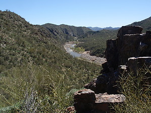


