username
X
password
register
for free!
help
  

Mormon Canyon, AZ

Guide 4 Triplogs  1 Topic
  4 of 5  
Fav
Wish
4
details
drive
permit
forecast
map
stats
photos
triplogs
topic
location
8 4 1
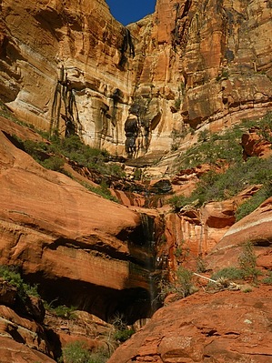
Canyons are inherently risky. Flash floods occur without notice on sunny days. Technical skills & surrounding topography knowledge required yet does not eliminate risk.
Canyoneering
Consensus
View 1
Grade1
WaterA
Risk
TimeII
Statistics
tap row or icons for details
Distance Round Trip 4 miles
Trailhead Elevation 4,552 feet
Elevation Gain 1,200 feet
Kokopelli Seeds 10
 Interest Off-Trail Hiking, Seasonal Waterfall & Seasonal Creek
unreported if dogs are allowed
editedit > ops > dogs to adjust
feature photo
Photos Viewed All MineFollowing
12  2023-09-28
Crest Trail #270B - Jct Sdl to Monte Vista Pk
Mike_W
34  2012-12-15
Brins Mesa Trail #119
chumley
8  2010-03-27 Vaporman
Author
author avatar Guides 16,843
Routes 17,472
Photos 24
Trips 1 map ( 6 miles )
Age 28 Male Gender
Location HAZ, TrailDEX
Historical Weather
Trailhead Forecast
Expand Map
Preferred Mar, Apr, Oct, Nov
Sun  6:03am - 6:48pm
0 Route
 
1 Alternative


remove free decal offer

Guide Needed
Publish Full Detail Guide


Use +Add above to share photos and triplogs
Overview: Either dive right into the lower wash of Mormon Canyon and follow it upstream to the main canyon coming off from Wilson Mt or hike along the Brins Mesa trail until it comes close to the canyon and then find the sidetrail that leads over to Mormon Canyon. Enjoy...


  • wilderness related
  • 2021 Verde Valley Trails
    region related
    2021 Verde Valley Trails
  • 2021 Verde Valley Area
    region related
    2021 Verde Valley Area
  • 2021 Sedona Trails Map
    region related
    2021 Sedona Trails Map


Check out the Triplogs.
Leave No Trace and +Add a Triplog after your canyon trip to support this local community.
WARNING! Hiking and outdoor related sports can be dangerous. Be responsible and prepare for the trip. Study the area you are entering and plan accordingly. Dress for the current and unexpected weather changes. Take plenty of water. Never go alone. Make an itinerary with your plan(s), route(s), destination(s) and expected return time. Give your itinerary to trusted family and/or friends.

 Permit $$
Red Rock Pass - may or may not be required. Go to Red Rock Pass then check "When is a Red Rock Pass Required?". If you have questions contact the Coconino forest service.

Red Rock - Secret Mountain Wilderness
see map for camping restrictions


 Directions
or
 Road
Paved - Car Okay

To canyon trip
In Sedona, drive up Jordan Rd to the Brins Mesa TH
page created by Vaporman on Mar 29 2010 5:34 pm
 90+° 8am - 6pm kills
helpcorrectionissue

end of page marker