username
X
password
register
for free!
help
  

Natural Bridge Trail - DVNP, CA

Guide 11 Triplogs  0 Topics
  3.5 of 5  
Fav
Wish
0
details
drive
permit
forecast
route  
stats
photos
triplogs
topics
location
90 11 0
Statistics
tap row or icons for details
Difficulty 2 of 5
Route Finding 1 of 5
Distance Round Trip 1.2 miles
Trailhead Elevation 387 feet
Elevation Gain 397 feet
Accumulated Gain 397 feet
Avg Time Round Trip 1 hour
Kokopelli Seeds 3.19
 Dogs not allowed
feature photo
Photos Viewed All MineFollowing
Inaugural Calculation on Button Tap!
15  2023-02-19
Death Valley - Badwater Road
trekkin_gecko
32  2023-02-19
Death Valley - Day 2
The_Eagle
20  2023-02-19
Death Valley - Badwater Road
johnlp
4  2021-03-10 Sun_Ray
5  2019-10-19 rcorfman
73  2017-02-17
Man Plans God Laughs
AZWanderingBear
8  2010-04-02 hippiepunkpirate
Author
author avatar Guides 25
Routes 36
Photos 2,890
Trips 658 map ( 2,277 miles )
Age 39 Male Gender
Location Peoria, AZ
Associated Areas
list map done
Death Valley Region
Historical Weather
Trailhead Forecast
Radar Map
Expand Map
Preferred Feb, Jan, Dec, Nov
Seasons   Early Autumn to Late Spring
Sun  5:21am - 6:11pm
Official Route & 2 Rts
 
1 Alternative


remove free decal offer
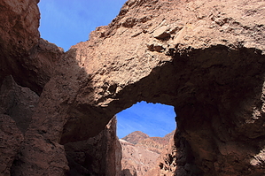
Bridge from Death
by hippiepunkpirate

The Natural Bridge Trail is one of Death Valley's most popular trails. The hike is a dusty one up a slot canyon to a rugged arch in the Amargosa Range. The parking lot is often packed, and solitude is nearly impossible unless you're into 120 degree heat. A wide trail runs up to and underneath the bridge, and continues up the canyon a ways. After the trail disappears, a slick-rock section is encountered, followed by an easily bypassed boulder clogging the slot canyon. The hike comes to a screeching halt at a twenty-foot slick-rock cliff.


The bridge itself is made out of the unconsolidated alluvium of the alluvial fan in which the canyon is carved. If you walk up to the canyon walls, the rock looks similar to soil, and will crumble when grabbed by human hands. The bridge is made of this same material. It definitely would not make for a safe crossing. Continuing up the canyon, a few interesting dry waterfall chutes can be seen in the alluvium. Slowly metamorphic country rock in the form of brilliant green serpentine replaces the rotten alluvial rock. Two beautiful peaks of the Amargosa Range can be seen above. After a short scramble up the serpentine slick-rock, a huge boulder clogs the slot canyon. Don't worry, a grown person can easily squeeze to the right. After a couple more short turns in the canyon, a twenty-foot serpentine cliff blocks your path. It could be climbable, but the serpentine is incredibly slick, a fall from that height might not be much fun. This is a short, relatively easy hike, but it is Death Valley, so be smart about water. Hike distance and elevation are estimated, but are close to reality.

2010-04-03 hippiepunkpirate


    Check out the Official Route and Triplogs.
    Leave No Trace and +Add a Triplog after your hike to support this local community.
    WARNING! Hiking and outdoor related sports can be dangerous. Be responsible and prepare for the trip. Study the area you are entering and plan accordingly. Dress for the current and unexpected weather changes. Take plenty of water. Never go alone. Make an itinerary with your plan(s), route(s), destination(s) and expected return time. Give your itinerary to trusted family and/or friends.

     Permit $$
    NPS


     Directions
    or
     Road
    FR / Jeep Road - Car possible when dry

    To hike
    From Furnace Creek in the Death Valley National Park, drive south .7 miles on highway 190. Turn right at junction for Badwater Basin. 12.9 miles down the road will be the signed turnoff for the Natural Bridge Trail. Trailhead is at the end of the bumpy dirt road (1.8 miles).
    page created by hippiepunkpirate on Apr 03 2010 9:56 pm
     90+° 8am - 6pm kills
    helpcorrectionissue

    end of page marker