username
X
password
register
for free!
help
  

Badlands Loop, CA

Guide 5 Triplogs  0 Topics
  4 of 5  
Fav
Wish
0
details
drive
permit
forecast
route  
stats
photos
triplogs
topics
location
83 5 0
Statistics
tap row or icons for details
Difficulty 1.5 of 5
Route Finding 1 of 5
Distance Lasso-Loop 2.66 miles
Trailhead Elevation 652 feet
Accumulated Gain 442 feet
Avg Time Round Trip 1.5
Kokopelli Seeds 4.87
 Backpack No
 Dogs not allowed
feature photo
Photos Viewed All MineFollowing
Inaugural Calculation on Button Tap!
20  2023-02-22
Death Valley - Day 5
trekkin_gecko
30  2023-02-22
Death Valley - Day 5
johnlp
30  2023-02-22
Death Valley - Day 5
The_Eagle
73  2017-02-17
Man Plans God Laughs
AZWanderingBear
10  2016-02-28 Lucyan
Author
author avatar Guides 27
Routes 61
Photos 2,620
Trips 700 map ( 4,689 miles )
Age 69 Male Gender
Location Phoenix, AZ
Associated Areas
list map done
Death Valley Region
Historical Weather
Trailhead Forecast
Radar Map
Expand Map
Preferred Feb, Nov, Jan, Dec
Seasons   Late Autumn to Early Spring
Sun  5:21am - 6:11pm
Official Route
 
1 Alternative


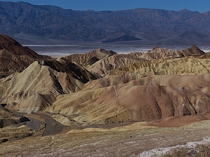
Bad can be Beautiful
by AZWanderingBear

Overview: Short loop from Zabriskie Point into the colorful Badlands of DVNP. Bring your camera.


Warning: There is no water at the trailhead or on the trail. Summer temperatures can be extremely high.
remove free decal offer
Hike: The trail begins near the first informational sign at the Zabriskie Point parking lot. A small notch cut into the first ridge line offers a fantastic view of the Badlands and Valley beyond. The initial descent is gradual along a smooth trail which can get muddy and slick after any rain. A half mile into the hike you are faced with a choice of doing the loop portion clockwise or counter clockwise. Either choice is good. Manly Beacon will be ahead and to your right at this point.

The loop is well signed. The western section of the loop is shared with the Gower Gulch Trail which offers the opportunity to descend west to the Golden Canyon trailhead or go north to the Golden Canyon Interpretive Trail.

Where the trail follows Gower Gulch and various side canyons you will find limestone and sandstone walls along with soft compressed mud walls, all from the ancient lake that once covered this area. See if you can spot rock slabs that still show ripple marks or the dried cracked mud patterns of a dry lake bed. Some of the upper canyon walls are topped with black volcanic ash and debris reminding us that Death Valley was recently geologically active and remains so today through uplift and erosion.

The climb back to the trailhead appears difficult but is actually mild. Before you are ready, this short gem of a hike is over and you back in the parking lot with the tour buses.

2017-02-24 AZWanderingBear


    Check out the Official Route and Triplogs.
    Leave No Trace and +Add a Triplog after your hike to support this local community.
    WARNING! Hiking and outdoor related sports can be dangerous. Be responsible and prepare for the trip. Study the area you are entering and plan accordingly. Dress for the current and unexpected weather changes. Take plenty of water. Never go alone. Make an itinerary with your plan(s), route(s), destination(s) and expected return time. Give your itinerary to trusted family and/or friends.

     Permit $$
    NPS


     Directions
    or
     Road
    Paved - Car Okay

    To hike
    From Las Vegas, follow US 95 west to Armagosa Valley, then NV 373 to Death Valley Junction. Follow Highway 190 25.6 miles to Zabriskie Point.
    page created by hippiepunkpirate on Feb 24 2017 10:52 pm
     90+° 8am - 6pm kills
    helpcorrectionissue

    end of page marker