Route Editor

| Guide | ♦ | 8 Triplogs | 0 Topics |
details | drive | permit | forecast | route |
stats |
photos | triplogs | topics | location |
| 182 | 8 | 0 |
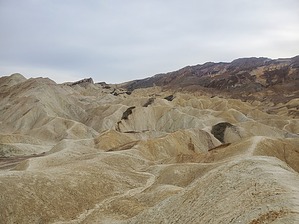
Featured on Death Valley Greatest Hits: Vol 1 by ShatteredArm The Gower Gulch/Golden Canyon loop is a popular hike near Furnace Creek, and one of the most accessible in the park. It offers something for everybody and has scenery that anybody can appreciate - featuring badlands and sand and rock in various colors. Hike The hike begins at the mouth of Golden Canyon (the parking lot will probably be full, but you can park along the shoulder of Badwater Road). Most hike this in a clockwise direction; but I think it makes sense to go counter-clockwise and get the 3/4-mile walk outside the canyons out of the way.
3/4 of a mile or so after entering the canyon, the wash starts to open up into the badlands. At about the 2.1-mile mark, you'll arrive at the junction with the trail that heads up to Zabriski Point. Head up this way if you desire to add a couple of miles onto your hike, or hang out in one of the most crowded spots in the park. Or, turn left (north) to continue the loop. After the second Zabriski Point spur, you'll climb up a gully to a ridge separating two drainages. A short detour to the south provides a great view of the upper reaches of Gower Gulch, including the throngs of people scuttling around the Point (they'll look like ants from here). A short descent and another short climb to the base of Manly Beacon (just under 3 miles in) puts you on the ridge separating Gower Gulch from Golden Canyon. Here there's a spur trail to the SW taking you to another viewpoint, and this area provides fantastic views of Golden Canyon. Leaving the ridge, the trail descends steeply down into Golden Canyon. Along the way, you'll get a nice view of the Red Cathedral. When you hit the wash, you can decide to head NE up the Red Cathedral spur. At this point, you're about a mile from the trailhead. Get ready to see loads and loads of tourists - don't get too upset, you're one of them! The numerous side trails and vibrant yellow and red colors should keep you distracted from the moving obstacles. Water Sources It is incredibly unlikely you'll find water in this area. Camping There are developed campgrounds a few miles away in Furnace Creek. The nearest dispersed camping is along Echo Canyon Road (free permit required as of 2022), or just east of the park boundary along HWY 190. Check out the Official Route and Triplogs. Leave No Trace and +Add a Triplog after your hike to support this local community. | ||||||||||||||||||||||||||||||||||||||||||||||||||||||||||||||||||||||||||||||||||||||||||||||||||||||||||||||||||||||||||||||||||||||||||||||||||||||||||||||||