Route Editor

| Guide | ♦ | 15 Triplogs | 0 Topics |
details | drive | permit | forecast | route |
stats |
photos | triplogs | topics | location |
| 74 | 15 | 0 |
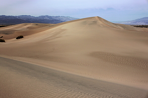
Luke, I am your father by hippiepunkpirate Some websites refer to this as the Stovepipe Wells Sand Dunes, but Mesquite Flat seems to be the most proper. For some reason, I have been referring to them as Panamint Dunes, which are located in the western part of Death Valley National Park in the Panamint Valley. The dunes described here are in Death Valley proper, between Stovepipe Wells and the Devil's Cornfield. Pop-Culture The Mesquite Flat Sand Dunes (and other areas around Death Valley) were one of the many desert filming locations for the original Star Wars movie. C3PO pitifully exclaiming "We're doomed!" is the scene most ingrained in my mind. For those further interested, there are many websites out there on the subject, including some sort of self-guided "Star Wars in Death Valley Tour".
Within the last year, NPS has built a brand new trailhead for this area, complete with pit toilets. There are no built trails on the dunes, but it is a plenty popular place to walkabout. From the trailhead, you will notice three dunes that rise above the others, and all seem to be of similar height. The one on the right seems to be most popular, the one in the middle almost as popular, and the one on the left not popular at all. Naturally, my group chose to go to the one on the left. For those directionally inclined, this would the northernmost dune. From the trailhead, it looks a bit farther to go to this dune, but it is likely a minimal difference of 1/4 of a mile each way. Being that you're going hiking on sand dunes, vegetation will be minimal. Just a few mesquite trees and creosote bushes at the edges. If you're lucky enough to come in the spring, the creosote may be blooming. Anyway, exploration out here is easy. Choose a destination and go! Being there is little vegetation, you can minimize the difficulty by following the contours and ridges very easily. Or, you can choose to just run straight up and down every single dune. I recommend a little of both. Since there is no trail, just make sure you remember where you parked the car. In the low spots between some of the dunes, you may find miniature playas with really cool mud cracks in them. Very cool, and very photogenic if you know what you are doing. Due to the popularity of this area, escaping the footprints of fellow humans is unlikely unless you want to walk a long way out. Remember that views are telescoped in Death Valley and a short distance may be miles farther away than you think. Check out the Official Route and Triplogs. Leave No Trace and +Add a Triplog after your hike to support this local community. | ||||||||||||||||||||||||||||||||||||||||||||||||||||||||||||||||||||||||||||||||||||||||||||||||||||||||||||||||||||||||||||||||||||||||||||||||||||||||||||||||||||||||||||||||||||||||||||||||