username
X
password
register
for free!
help
  

Bridge Spring Arch, NV

Guide 9 Triplogs  0 Topics
  3.5 of 5  
Fav
Wish
0
NV > Vegas
details
drive
permit
forecast
route  
stats
photos
triplogs
topics
location
18 9 0
Canyons are inherently risky. Flash floods occur without notice on sunny days. Technical skills & surrounding topography knowledge required yet does not eliminate risk.
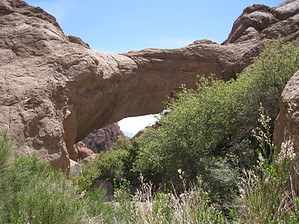
Statistics
tap row or icons for details
Difficulty 1.5 of 5
Route Finding 2 of 5
Distance One Way 0.8 miles
Trailhead Elevation 3,505 feet
Elevation Gain 160 feet
Accumulated Gain 220 feet
Avg Time One Way 1 hour
Kokopelli Seeds 1.53
 Interest Off-Trail Hiking & Perennial Waterfall
 Backpack Possible - Not Popular
feature photo
Photos Viewed All MineFollowing
6  2013-02-02
Oak Creek / Lonesome Wash Exploration
autumnstars
18  2010-04-23 AZLOT69
Author
author avatar Guides 177
Routes 249
Photos 10,213
Trips 2,215 map ( 17,459 miles )
Age 74 Male Gender
Location Gold Canyon, AZ
Historical Weather
Trailhead Forecast
Radar Map
Expand Map
Preferred Nov, Dec, Jan, Feb → 8 AM
Seasons   Early Winter to Early Spring
Sun  5:15am - 6:00pm
Official Route
 
0 Alternative


remove free decal offer
Natural High Arch
by AZLOT69

Overview: Bridge Spring Arch is a natural bridge cut into mudstone by Techatticup Wash. The source of Techatticup wash is Bridge Spring. Getting there requires an open desert hike just less than a mile one way to see the natural bridge which has a span of about twenty five feet.


Hike: The hike starts at the top of a hill with nice views all around. To the east, the road you just arrived on takes a plunge down to the town of Nelson which can be seen to the east. The topography from here continues its dramatic drop east all the way to the Colorado River. The trail follows a ridgeline southeast with some minor drops and rises. The trail is well established at this point and easy to follow. Vegetation is scarce and there is no hope of shade. Entering a wash the trail heads in a more easterly direction. The trail becomes less defined at this point but the wash gets more defined. Stay in the wash as it meanders past several photogenic rock outcroppings. The wash threads its way between two mountains continuing its travel eastward. Ever so gradually the walls on either side get taller and the wash gets rockier. Eventually this leads to some minor scrambling. Pick and choose the best route from the limited choices available. On the final approach to the natural arch the vegetation gets thick requiring a move from the wash high left or right. The wash makes a shift south at this point revealing the natural arch. Vegetation is thick here but no too aggressive. It does require some thought for good pictures. A little bouldering will get you thru the arch for a varied angle of this formation. Return the way you came.

2010-04-27 AZLOT69


    Check out the Official Route and Triplogs.
    Leave No Trace and +Add a Triplog after your canyon trip to support this local community.
    WARNING! Hiking and outdoor related sports can be dangerous. Be responsible and prepare for the trip. Study the area you are entering and plan accordingly. Dress for the current and unexpected weather changes. Take plenty of water. Never go alone. Make an itinerary with your plan(s), route(s), destination(s) and expected return time. Give your itinerary to trusted family and/or friends.

     Permit $$

     Directions
    or
     Road
    Paved - Car Okay

    To canyon trip
    From Las Vegas, drive south on Highway 95 where it splits from Highway 93 near Railroad Pass, turn left on Highway 165 in about 10 miles, then drive 9.5 miles before turning left on a gravel road and park immediately. The trail starts at the end of the dirt road to the east about one hundred yards.
    page created by AZLOT69 on Apr 27 2010 11:40 am
     90+° 8am - 6pm kills
    helpcorrectionissue

    end of page marker