Route Editor

| Guide | ♦ | 3 Triplogs | 0 Topics |
details | drive | permit | forecast | route |
stats |
photos | triplogs | topics | location |
| 15 | 3 | 0 |
Canyons are inherently risky. Flash floods occur without notice on sunny days. Technical skills & surrounding topography knowledge required yet does not eliminate risk.
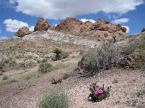
This Is No Card Game by AZLOT69 Hike: The hike can be accomplished in either direction but is described here in a counter clockwise direction. Taking the Bridge Spring Arch hike, at about one third of a mile, an unnamed wash joins from the left. Turn left here staying high on either side of the wash for the first fifty feet. This will get you around a tall dry fall. Once above the dry fall stay in the wash and follow it to the next Y junction with another unnamed wash. Take the branch to the right and work your way high right staying out of the wash. The vegetation is too thick in the wash. Once you gain some altitude you will notice a cave ahead left on the opposing mountainside. This is your immediate destination. Simply take the easiest route. From the cave look right for a low natural arch. It may initially be difficult to see as the are rocks behind it hiding the fact that there is an arch there. Now look back to the cave and climb up the left side of the cave. There is a scree filled chute ahead which is a passage to the ridgeline. It is slick rock on top and there is very little vegetation. You can now clearly see your way as the bushwhack follows the ridgeline like a rollercoaster over to Lonesome Draw. There are several more natural arches to discover along with splendid views in all directions. Lonesome draw on the north end of the ridge is distinguished by the steep decline. It is mostly slick rock and not too hard to negotiate. Once down a ways start following the contour around to the left. It can be steep at times with some scree but the vegetation stays light. Continue contouring left as you are making a u turn and returning via the west side of the ridgeline. Work down onto the flat land and soon you will be able to see your vehicle parked at the trailhead. Continue to a deep wash that heads south. At each subsequent junction bear right. Soon you connect back to the Bridge Spring Arch Trail. Turning right brings you back to the Bridge Spring Arch trailhead. Check out the Official Route and Triplogs. Leave No Trace and +Add a Triplog after your canyon trip to support this local community. | ||||||||||||||||||||||||||||||||||||||||||||||||||||||||||||||||||||||||||||||||||||||||||||||||||