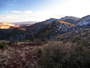
Overview: Apache-Sitgreaves National Forest info: This trail includes collapsed mines, springs, pyrite (fool's gold), and Eagle Creek at the end. There are petroglyphs on Painted Bluff, about 500 feet above the trail.
WARNING! Hiking and outdoor related sports can be dangerous. Be responsible and prepare for the trip. Study the area you are entering and plan accordingly. Dress for the current and unexpected weather changes. Take plenty of water. Never go alone. Make an itinerary with your plan(s), route(s), destination(s) and expected return time. Give your itinerary to trusted family and/or friends.
Permit $$
None
Directions
Road
Paved - Car Okay
To hike From Safford, head east on Highway 70/191. 10 miles from Safford, the highway splits; turn left onto Highway 191 and follow it for another 23.75 miles to a highway junction known as 3-Way (old drive-in movie theater and store). Turn left to remain on Highway 191. From the 3-Way junction, head north on highway 191 for approximately 27.85 miles to a switchback near milepost 177. There is limited parking along the highway at the switchback. There are no trail signs at the highway, they appear at the west end of the old quarry, 0.2 miles into the hike.
page created by PrestonSands on May 04 2008 1:48 pm
 Route Editor

 Overview: Apache-Sitgreaves National Forest info: This trail includes collapsed mines, springs, pyrite (fool's gold), and Eagle Creek at the end. There are petroglyphs on Painted Bluff, about 500 feet above the trail.