Route Editor

| Guide | ♦ | 9 Triplogs | 0 Topics |
details | drive | no permit | forecast | route |
stats |
photos | triplogs | topics | location |
| 121 | 9 | 0 |
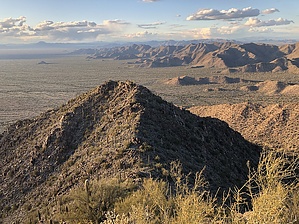
Will hike for beer by desert_boonie  If you are looking for an off-trail rugged peak to hit up, then head on down to the Southern Maricopa Mountains. If you are looking for an off-trail rugged peak to hit up, then head on down to the Southern Maricopa Mountains.The Big Horn BM is visible from the interstate and sticks out begging to be hiked. Few people hike in the Maricopa mountains, and I mean a few monthly. Chances are you will not see a single soul if you head on down to this area so be prepared. Here's the hike.
From the end of the road, go right (east) to the wash about 100 feet away. You cannot miss it, it is the only wash heading in from the area surrounded by the smaller peaks around. Once in the wash, you will be hiking in some sandy terrain so get ready for that great feeling of sand in your shoes. Unless there was a rainstorm in the last few days, you will not see a single drop of water in it which is good or bad depending on how you feel about it. Continue in the wash where you will lose sight of the peak a few times but you are always heading right towards it. After a mile in the wash, you will be at the southern base of the mountain and can start up here. You could also continue in the wash another half mile or so and hit the eastern ridge which you will see sticking out that looks to go straight to the peak. If you get out and start up the southern end, you will have a few drops but nothing major. That is what will be described here. Out of the wash and about to head up the southern ridge at 2.28 miles, you will start the great game of cholla dodging. Plenty of this unwanted cactus at the bottom of the mountain will keep you on your toes, also the start of the mountain is very steep and the footing is loose so be careful while going up at the start. Once you get up to the ridge, you will have the summit in view the entire time and she never looks too far away. You will make two drops on the southern ridge but neither are very bad or too much in elevation loss. The cholla will start to thin out and you will not have too much of them to worry about on the ridge, but always make sure you see the ones that are there. As you make your way towards the summit and to the top half of the mountain, there will be more and more larger boulders to scramble up. Nothing to really climb so you will not have to worry about that aspect. Just watch out for the spider webs in every other crack in the rocks towards the top. You will know you are about to top out, it just levels out pretty good at the top. Once on top you will find the red register can where just over 20 people have signed in since 1996. The views are great as you get to see the Maricopas all around you, mainly to the north where the High Point of the range is just NE of the summit you are now on. You will see the route you came up very well once on top and can return the same way. Or if you want to get in the wash quicker head down the eastern ridge where you could have hiked up. It will add some mileage, but shouldn't be too much. Once you go down, just make sure your footing is good as the rock gets loose. Dodge the cholla again and get back into the wash and back the way you came. No cairns along the way but hey, you do not need them and there shouldn't be any. A topo map of the area would come in handy, but again you will have the peak in sight 99% of the time so you will not get lost. Enjoy what the desert has to offer, it is very beautiful. Check out the Official Route and Triplogs. Leave No Trace and +Add a Triplog after your hike to support this local community. | |||||||||||||||||||||||||||||||||||||||||||||||||||||||||||||||||||||||||||||||||||||||||||||||