 Route Editor

| Guide | ♦ | 1 Triplog | 0 Topics |
details | drive | no permit | forecast | map |
stats |
photos | triplog | topics | location |
| 7 | 1 | 0 |
pretty AND pointless by PrestonSands   This hike describes West Coal Creek canyon, in Arizona's Big Lue Mountains, near the Arizona-New Mexico border. West Coal Creek offers an easy hike through the pine forest along an old jeep trail and is conveniently located near Coal Creek Campground. Nothing is exciting about this hike, but it does provide something to do if you are camped at Coal Creek Campground. This hike describes West Coal Creek canyon, in Arizona's Big Lue Mountains, near the Arizona-New Mexico border. West Coal Creek offers an easy hike through the pine forest along an old jeep trail and is conveniently located near Coal Creek Campground. Nothing is exciting about this hike, but it does provide something to do if you are camped at Coal Creek Campground.Forest road 8344 comes down West Coal Creek canyon, from the south, to meet state highway 78, 0.1 miles east of Coal Creek Campground. Parking and camping are available at the beginning of forest road 8344. No signs identify forest road 8344.
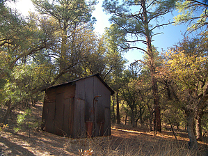
The jeep trail follows West Coal Creek's dry creek bed, through vegetation typical of the Big Lue Mountains: tall ponderosa pines, with an understory of white oaks and alligator junipers. Hiking is easy and elevation gain is slight. At 0.35 miles, the trail reaches a small, open spot, where there is a concrete water trough (dry), and a small, rusty, metal shack. The shack is the site of "West Coal Creek Well". The well, which is inside the shack, is missing its pump and other parts. There is no water available. The pump shack area offers camping possibilities, for those looking to do a short backpacking trip. Where the jeep trail comes to an end at the well, a couple of faint ATV trails lead further up the canyon, into the pines. These ATV trails soon come to an end, at about 0.5 miles. This is where I turned around. One could continue up to the head of West Coal Creek, at a distance of 1.6 miles from Highway 78, but there is little else to see. Return the way you came. Check out the Triplog. Leave No Trace and +Add a Triplog after your hike to support this local community. | |||||||||||||||||||||||||||||||||||||||||||||||||||||||||||||||||||||||||||||||||||


