Oak Grove Canyon, AZ

Guide 10 Triplogs Mine 0 1 Topic
 
4 of 5 
Fav
Wish
0
details
drive
no permit
forecast
route  
stats
photos
triplogs
topic
location
219 10 1
Canyons are inherently risky. Flash floods occur without notice on sunny days. Technical skills & surrounding topography knowledge required yet does not eliminate risk.
Statistics
tap icons for details
Difficulty 1.5 of 5
Route Finding 1 of 5
Distance Round Trip 5 miles
Trailhead Elevation 3,232 feet
Elevation Gain 459 feet
Accumulated Gain 611 feet
Avg Time Round Trip 5 hours
Kokopelli Seeds 8.06
 Interest Off-Trail Hiking & Perennial Creek
feature photo
Photos Viewed All MineFollowing
Inaugural Calculation on Button Tap!
7  2017-12-03 RickVincent
33  2017-03-02
Turkey Creek Canyon
Oregon_Hiker
50  2014-12-07
Turkey Creek - Eastern Ridge
CannondaleKid
38  2014-12-06
Rug Road via Oak Grove Canyon
CannondaleKid
15  2014-11-16 RickVincent
22  2014-03-16 SkyIslander18
24  2012-11-22 RickVincent
4  2012-10-13 ssk44
Page 1,  2
Author
author avatar Guides 4
Routes 5
Photos 3,371
Trips 767 map ( 3,696 miles )
Age 53 Male Gender
Location Mesa, AZ
Historical Weather
Trailhead Forecast
Radar Map
Expand Map
Preferred Oct, Nov, Mar, Apr → 7 AM
Seasons   Early Spring to Late Autumn
Sun  5:21am - 7:16pm
Official Route
 
1 Alternative
 
 Water
Nearby Area Water
[ View More! ]
Flora  Nearby
Geology  Nearby
Meteorology  Nearby
Named place  Nearby
Culture  Nearby
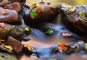
Where are the oaks?
by RickVincent

 
Overview
A lush winding canyon surrounded by steep canyon walls with a slow running perennial creek running down the center. Water appears to come from springs and disappears underground in a few places. Don't be surprised if the creek bed is dry near the mouth of the canyon.Hike
The trailhead is not marked but is an obvious dirt pull-out that is just a few hundred feet shy of the mouth of the canyon. You can keep going and drive all the way up to the canyon, that is if you haven't had enough of the Arizona pinstriping you've already acquired on your approach to the trailhead. There are signs just inside the canyon that warn against further motor vehicle use beyond the posted area.

The route is completely off-trail. Occasional game trails make for the easiest travel, but most of the hike involves boulder hopping, creek crossings, and a bit of bushwhacking. The canyon gets better and better as its sheer walls tower above you 200-300 feet. The walls are vertical and in some areas deeply undercut, creating a canopy of stone around the winding curves. I didn't see any "oaks" like the name hints, but there are plenty of sycamores, cottonwood, sumac, and one small stand of maples.

At about 1.5 miles in you will begin to notice a pair of stone spires towering about 200 feet above the canyon. Not long after this, you will come to a seemingly impassable boulder jam (van size boulders). I tried climbing up a cliff to the left but ended up too high. I stowed my camera gear and bouldered my way through the obstacle. As an alternate, you could try one of a couple of game trails that meander up a slope between the stone spires. I returned this way, wanting to get an overhead view of the canyon from above the tree line.

Once you pass the twin spires, the canyon opens up, the creek has completely disappeared and overall the hike becomes less interesting. I continued for about 1/2 mile beyond this point, enjoying the solitude and the fall colors of the sycamore.

Camping
There are several forested pull-outs along Turkey Creek to camp. Many spots already have a fire ring. If you find any fire rings near the cliff walls, please move them away from the cliffs. Fires too close to the cliff create ugly black smoke scars on the cliff walls.

Check out the Official Route and Triplogs.

Leave No Trace and +Add a Triplog after your canyon trip to support this local community.

2012-11-25 RickVincent
    WARNING! Hiking and outdoor related sports can be dangerous. Be responsible and prepare for the trip. Study the area you are entering and plan accordingly. Dress for the current and unexpected weather changes. Take plenty of water. Never go alone. Make an itinerary with your plan(s), route(s), destination(s) and expected return time. Give your itinerary to trusted family and/or friends.

     Permit $$
    None


     Directions
    or
    or
     Road
    High Clearance possible when dry

    To canyon trip
    Follow directions that lead to the east side trailhead of Aravaipa Canyon. Continue beyond the designated trailhead for Aravaipa Canyon for 1.8 miles to Turkey Creek. Turn left at Turkey Creek. The road is unmaintained and a 4x4 is highly recommended, although an experienced driver in a high clearance 2wd will get you there. Travel 2.5 miles to pull out on road left. Expect plenty of new Arizona pin-striping by the time you reach the parking area.
    page created by ssk44 on Nov 25 2012 3:51 pm
     90+° 8am - 6pm kills
    prehydrate & stay hydrated
    helpcorrectionissue

    end of page marker