username
X
password
register
for free!
help
 This is likely a great time to hike this trail!  Check out "Preferred" months below, keep in mind this is an estimate.
 

Fain Park Trails - Prescott Valley, AZ

Guide 24 Triplogs  0 Topics
  1.3 of 5  
Fav
Wish
0
details
drive
no permit
forecast
map
stats
photos
triplogs
topics
location
0 24 0
HAZ reminds you to respect the ruins. Please read the Archaeological Resources Protection Act of 1979 & Ruins Etiquette
Statistics
tap row or icons for details
Difficulty 1 of 5
Distance Round Trip 1.75 miles
Trailhead Elevation 5,078 feet
Elevation Gain 120 feet
Accumulated Gain 250 feet
Kokopelli Seeds 3
 Interest Ruins & Seasonal Creek
Photos Viewed All MineFollowing
38  2015-07-25
Prescott Lakes Tour
outdoor_lover
Author
author avatar Guides 16,843
Routes 17,472
Photos 24
Trips 1 map ( 6 miles )
Age 28 Male Gender
Location HAZ, TrailDEX
Associated Areas
list map done
Prescott Region
Historical Weather
Trailhead Forecast
Expand Map
Preferred May, Jun, Sep, Oct
Sun  6:05am - 6:50pm
0 Route
 
0 Alternative


remove free decal offer

 Likely In-Season!
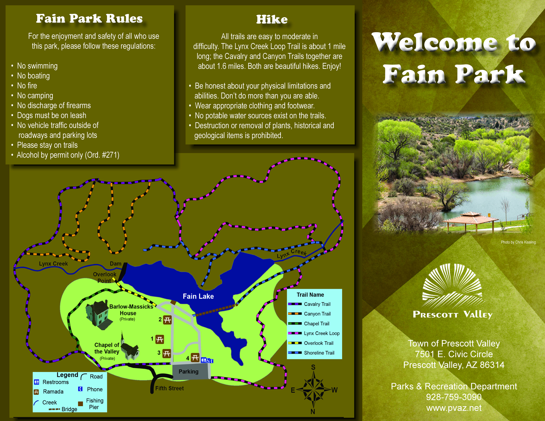
Overview: Prescott Valley's Fain Park is located along Lynx Creek just south of Highway 69, and features several signed interconnecting trails that loop around the park. Mileage will vary depending on the trail you choose.

Fain Park offers picnic ramadas, limited gold panning, a refurbished stamp mill, the Barlow-Massick "Castle on the Creek", and the Fitzmaurice historic ruins. The town has not yet developed the historic townsite of Massicks. Neither the Castle nor the Fitzmaurice ruins are open to the public. Fain Lake is stocked by Arizona Game and Fish with rainbow trout. Swimming, campfires, and overnight camping are not allowed.


Cavalry Trail
Canyon Trail
Chapel Trail
Lynx Creek Loop
Overlook Trail
Shoreline Trail
view map

2018-07-14 HAZ_Hikebot
  • Fain PDF
    guide related
    Fain PDF


Check out the Triplogs.
Leave No Trace and +Add a Triplog after your hike to support this local community.
WARNING! Hiking and outdoor related sports can be dangerous. Be responsible and prepare for the trip. Study the area you are entering and plan accordingly. Dress for the current and unexpected weather changes. Take plenty of water. Never go alone. Make an itinerary with your plan(s), route(s), destination(s) and expected return time. Give your itinerary to trusted family and/or friends.

 Permit $$
None


 Directions
or
 Road
Paved - Car Okay

To hike
From Prescott, travel east on Highway 69 to Prescott Valley. Turn right (south) at the Prescott East Highway stoplight, and follow the signs to Fain Park (less than a mile south of Highway 69 along Lynx Creek).
page created by PrestonSands on May 10 2010 12:08 am
 90+° 8am - 6pm kills
helpcorrectionissue

end of page marker