username
X
password
register
for free!
help


Turkey Creek Cliff Dwelling, AZ

Guide 26 Triplogs  0 Topics
  3.3 of 5 
Fav
Wish
10
details
drive
no permit
forecast
route  
stats
photos
triplogs
topics
location
453 26 0
HAZ reminds you to respect the ruins. Please read the Archaeological Resources Protection Act of 1979 & Ruins Etiquette
Statistics
tap icons for details
Difficulty 0.5 of 5
Route Finding 1 of 5
Distance Round Trip 0.1 miles
Trailhead Elevation 3,208 feet
Elevation Gain 74 feet
Accumulated Gain 74 feet
Avg Time Round Trip 10 minutes
Kokopelli Seeds 0.47
 Interest Ruins & Historic
unreported if dogs are allowed
editedit > ops > dogs to adjust
feature photo
Photos Viewed All MineFollowing
Will recalculate on button tap!
25  2022-06-11
Aravaipa Canyon
Ashleyannmarie
10  2020-11-30
Aravaipa Canyon Wilderness - GET #7
GrangerGuy
23  2020-11-14
Aravaipa Canyon Wilderness - GET #7
John10s
30  2017-12-08
East Aravaipa
chumley
14  2017-03-28 Steph_and_Blake
14  2015-05-08 kingsnake
23  2015-05-07
Turkey Creek Camping
rwstorm
1  2015-02-07 FOTG
Page 1,  2,  3
Author
author avatar Guides 34
Routes 249
Photos 2,197
Trips 592 map ( 4,584 miles )
Age 36 Male Gender
Location Portland, OR
Associated Areas
list map done
Globe Region
Historical Weather
Trailhead Forecast
Radar Map
Expand Map
Preferred Nov, Feb, Mar, Jan
Seasons   ALL
Sun  5:14am - 7:27pm
Official Route
 
4 Alternative
 
 Water


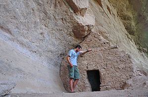
Super short, super easy!
by keepmoving

 
BLM Overview
The Turkey Creek cliff dwelling is one of the most intact structures of its kind in southeastern Arizona. It was probably occupied for a few months each year by prehistoric farmers around 1300 AD. These people, of the Salado culture, probably collected plants along Turkey Creek, grew corn and hunted wild animals. Salado farmers disappeared suddenly around 1450 AD.


Hike
This is an extremely short trail that is worth a visit from anyone visiting Aravaipa East. From the trailhead on Turkey Creek, the trail heads north a short way as it parallels the road. Soon the trail begins to head more to the Northwest as it approaches the cliff wall that is mostly hidden behind the trees that line the canyon. At the base of the hill, the trail encounters an informational sign that explains the history of the cliff dwelling you are about to visit. Past the sign, the trail climbs a series of loose, rocky stone steps with the aid of a guard rail. At the top of the hill, you are greeted with another small sign from the BLM that provides additional history of the ruins & warns visitors to avoid defacing the dwelling. Explore the dwelling and return to the trailhead via the same route.

Check out the Official Route and Triplogs.

Leave No Trace and +Add a Triplog after your hike to support this local community.

2012-06-03 keepmoving
    WARNING! Hiking and outdoor related sports can be dangerous. Be responsible and prepare for the trip. Study the area you are entering and plan accordingly. Dress for the current and unexpected weather changes. Take plenty of water. Never go alone. Make an itinerary with your plan(s), route(s), destination(s) and expected return time. Give your itinerary to trusted family and/or friends.

     Permit $$
    None


     Directions
    or
    or
     Road
    High Clearance possible when dry

    To hike
    From the Aravaipa East trailhead, continue 2 miles down the road to the Aravaipa Wilderness Boundary. From there, make a left turn (the only direction you can drive) and follow Turkey Creek Rd. The trailhead is located 1.4 miles up Turkey Creek road and will be on your right. You will know you are close to the trailhead when the road passes through a small corral, at which point the trail is only 500 feet further ahead.

    Note- Turkey Creek is a rather narrow road and you will be guaranteed to obtain some pinstripes!
    page created by ssk44 on Jun 03 2012 12:03 pm
     90+° 8am - 6pm kills
    helpcorrectionissue

    end of page marker