Route Editor

| Guide | ♦ | 3 Triplogs | 0 Topics |
details | drive | no permit | forecast | route |
stats |
photos | triplogs | topics | location |
| 21 | 3 | 0 |
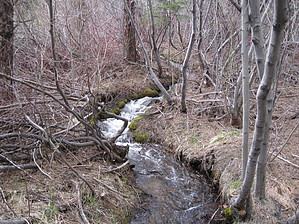
To See What Is On The Other Side by AZLOT69 Hike: The hike starts across the road from where you park. It starts to gain elevation immediately but its moderate as this trail is mountain bike friendly as well. Continue straight when you come to a water supply tank on your left. Another water tank fenced in will signal the trail making a sharp switchback. You are near the saddle now which offers a nice vista of Washoe Valley. Down the other side of the saddle brings you to an intersection. This is where your lasso loop begins. You can accomplish it either way but for this description it is described in a clockwise fashion. Staying left the trail gives back the five hundred feet you gained to get over the saddle down to a creek bed. Springtime will have quite a flow due to melting snow. This is Brown's Creek and there is a foot bridge over it. About eighty percent of this trail has tree cover. Soon you come to another creek. It's a renegade creek that is unnamed and only flows in the spring time. There is also a footbridge over this creek. Soon you arrive at another renegade creek if hiking in the spring. The trail will not cross this creek but stay on the right bank as you start the five hundred foot gain back up to the saddle. Again the trail is moderate and soon you arrive at an intersection where you want to make a sharp right. The trail contours around the mountain a comes to another footbridge at Brown's Creek again. In another quarter mile you rejoin the original trail turning left to return the way you came. Check out the Official Route and Triplogs. Leave No Trace and +Add a Triplog after your hike to support this local community. | ||||||||||||||||||||||||||||||||||||||||||||||||||||||||||||||||||||||||||||||