Route Editor

| Guide | ♦ | 19 Triplogs | 0 Topics |
details | drive | no permit | forecast | 🔥 route |
stats |
photos | triplogs | topics | location |
| 404 | 19 | 0 |
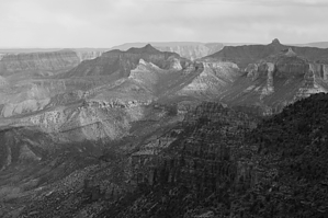
Saddle below the Saddle by hippiepunkpirate  Overview OverviewNankoweap Trail #57 is most commonly used to access the Nankoweap Trail proper, which in turn descends harrowingly to the Colorado River. Principally used for backpacking, this description instead utilizes the #57 trail as a day hike from the Saddle Mountain TH to the saddle overlook at the beginning of the Nankoweap Trail proper. Hike From the Saddle Mountain TH, head south up the wide trail past the sign that notifies your entry into the Saddle Mountain Wilderness. For the first three-quarters of a mile, you will walk steadily uphill. Springtime may afford a lovely display of wildflowers along this first section. At some point, you will see a sign that says "Saddle Mountain Trail" (which is #31), and that is fine; you are going the right way. At the crest of the hill, the trail will drop abruptly into a 350-foot deep canyon. Views open up so you can see Saddle Mountain itself looming above and the saddle overlook just to its right (which is the destination of this hike).
You are solely on #57 now. It crosses the wash numerous times at this point. I'm not certain how often the creek runs, but it should be dry most of the year. My May 2010 hike featured small puddles here and there in the wash, so assume it was flowing sometime during the spring snowmelt. Eventually, the trail begins climbing uphill. The effects of a wildfire are noticeable in this area. Through the trees, you can see the tilted sedimentary strata on Saddle Mountain to your left. The hill you are climbing is tilted Esplanade Sandstone, turned up at an angle by the East Kaibab Monocline. The hill does not get incredibly steep but is a steady and relentless climb to the saddle. Just before the saddle is the junction for the Nankoweap Trail; continue straight. A big view of the Grand Canyon opens up before you. At about 7,600 feet, you stand higher than the South Rim. Palisades of the Desert is visible far across the canyon. Much of the Grand Canyon Super Group strata are visible. Solitude is likely, and not having a crowd is a guarantee. The motivated hiker might try making it 3 miles further up #57 to the other trailhead on the North Rim, but the view from the saddle seems a good enough reward for me. I enjoyed this hike as a North Rim type experience before the North Rim opened for the summer on May 15th. If you are camping in the House Rock Valley area, this is a great option. If you are in the area when the North Rim is open, that is likely a more rewarding option than this particular hike, but this is likewise a good hike. The destination is better than the journey for this one. Check out the Official Route and Triplogs. Leave No Trace and +Add a Triplog after your hike to support this local community. | |||||||||||||||||||||||||||||||||||||||||||||||||||||||||||||||||||||||||||||||||||||||||||||||||||||||||||||||||||||||||||||||||||||||||||||||||||||||||||||||||||||||||||||||||||||||||||||||||||||||||||||||||||||||||