 Route Editor

| Guide | ♦ | 3 Triplogs | 0 Topics |
details | drive | no permit | forecast | route |
stats |
photos | triplogs | topics | location |
| 15 | 3 | 0 |
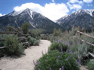
Peak Behind The Fence by AZLOT69  Hike: The paved trailhead has a kiosk with a map of connecting trails but no facilities. This hike can be done in either direction, as a shuttle, key exchange, or out and back, connecting with other trails. The hike is described here from north to south. The trail starts out following attractive buck and rail fencing, offering picturesque views of the towering Sierra. There is no shade as the vegetation is mostly wild sage, brush, and tumbleweed. It is common to see lizards darting about and no doubt you will scare up a few rabbits, perhaps a black tailed jack rabbit. In about a half mile the trail turns west toward the mountains. A steady climb brings you to some attractive rock outcroppings and soon you are in the tall pines. The trail rejoins some buck and rail fencing here as it turns south. The first of several creek crossings is next. Springtime will find these creeks certainly running with fresh clear cold water. The chances for water diminish greatly as summer sets in. The trail continues to gain altitude as it enters federal land without any fanfare. There are panoramic views of Carson Valley off to the left. The forest service has been pro active managing the forest in this area and the mature forest is attractive. As a reminder that civilization is not far away you come to a paved road. The trail continues on the other side making its way to the high point. Without any notice you are actually entering California at this point. From here the trail begins its serpentine wiggle down, eventually giving back all the elevation. A larger creek crossing here utilizes a neatly chiseled log bridge to cross. Soon a marked intersection is for the Valley View Loop on your left. Shortly after, another intersection appears on your right. This is for the Lonesome Trail. The gentle descent continues down to the end of the trail where it meets Sandy Trail. To complete the thru hike to the Faye-Luther Trailhead bear left on Sandy Trail .3 miles to the trailhead, or return the way you came. Check out the Official Route and Triplogs. Leave No Trace and +Add a Triplog after your hike to support this local community. One-Way Notice This hike is listed as One-Way. When hiking several trails on a single "hike", log it with a generic name that describes the hike. Then link the trails traveled, check out the example. | |||||||||||||||||||||||||||||||||||||||||||||||||||||||||||||||||||||||||||||||||||||


