Route Editor

| Guide | ♦ | 1 Triplog | 0 Topics |
details | drive | permit | forecast | route |
stats |
photos | triplog | topics | location |
| 15 | 1 | 0 |
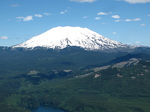
Hike to a peak with 360 views! by sagamihara_hiker The rocky outcrop at the top gives you 360 degree views to the surrounding area. One of the premiere hikes with views in the area. On the way back down, take the faint side trail at the second switchback about 0.8 miles to sugarloag ridge which offers another rocky outcrop to get good views. From Portland/Vancouver, take I-5 North to Woodland, exit 21 and head East for 31 miles, following the signs for Cougar. 3.2 miles past Cougar turn right on an unmarked paved road (if you past the sign for the end of Highway 503 spur you've gone too far). Take the unmarked road for 0.3 miles. After crossing a bridge, turn left on an unmarked gravel road. Follow it for 1.6 miles and turn right on a gravel road marked "10". Take that road for 2.4 miles (almost all uphill). After 2.4 miles fork right and take this road 0.2 miles to the trailhead at the end. Some potholes and lots of gravel but should be passable by almost any car. Check out the Official Route and Triplog. Leave No Trace and +Add a Triplog after your hike to support this local community. | ||||||||||||||||||||||||||||||||||||||||||||||||||||||||||||||||||||||||||||||||||||||