Route Editor

| Guide | ♦ | 10 Triplogs | 0 Topics |
details | drive | no permit | forecast | route |
stats |
photos | triplogs | topics | location |
| 148 | 10 | 0 |
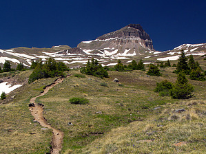
Uncomparable! by PrestonSands Warning: As with any hike above treeline, be sure to start early to avoid thunderstorms.
The easily followed track of the Uncompahgre Peak Trail heads into the trees, and soon begins following Nellie Creek. The trail quickly reaches treeline, where Uncompahgre Peak comes into view, at the west end of a large basin. The trail climbs a low bluff on the north side of Nellie Creek, where it reaches a signed junction with the Big Blue Trail at 0.9 miles. The trail steadily gains elevation while heading west, straight for Uncompahgre Peak. A mile west of the Big Blue Trail junction, our trail turns south toward the prominent south ridge of Uncompahgre Peak. Passing a trail sign for Matterhorn Creek, the trail hits the south ridge at 13,000 feet. It climbs steadily while staying high on the south ridge's eastern face, aiming for the south edge of the peak. A few switchbacks bring the trail to the crest of Uncompahgre Peak's south ridge, at 13,800 feet. The trail crosses over to the west side of the ridge at this point, and fades slightly in a steep rock slide, below a few hoodoo rock formations. At this point, you'll need to scale one of the two chutes above you. You should be able to see where others have scrambled up. There is nothing technical, but you don't want to slip here, so be careful. After a hundred vertical feet or so, the chutes reach the top of Uncompahgre's cliffs (38.06848 N, -107.46194 W). The trail resumes here and climbs the last bit of ridge to the south edge of the tilted summit platform, reaching the true summit in another quarter of a mile. The summit is a broad open flat that suddenly gives way to a dramatic one thousand foot cliff along its northern edge. The view is spectacular, with hundreds of other high peaks spread out in every direction. Welcome to the highpoint of the San Juan Mountains. Check out the Official Route and Triplogs. Note This is a moderately difficult hike. Leave No Trace and +Add a Triplog after your hike to support this local community. | ||||||||||||||||||||||||||||||||||||||||||||||||||||||||||||||||||||||||||||||||||||||||||||||||||||