 Route Editor

| Guide | ♦ | 19 Triplogs | 0 Topics |
details | drive | no permit | forecast | 🔥 route |
stats |
photos | triplogs | topics | location |
| 269 | 19 | 0 |
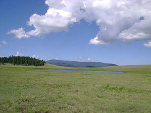
I hear the whistle blowin' by azbackpackr  This trail is unusual because, although it is designated non-motorized in summer, snowmobiles are allowed in winter. It is best done on a mountain bike, but I have seen people hiking it, too. Horse riders also use it. It is kind of flat for hiking but perfect for a summer's day mountain bike ride. I have cross-country skied along it. It is ok for beginners to do that sport but doesn't have enough hills for more advanced skiers. This trail is unusual because, although it is designated non-motorized in summer, snowmobiles are allowed in winter. It is best done on a mountain bike, but I have seen people hiking it, too. Horse riders also use it. It is kind of flat for hiking but perfect for a summer's day mountain bike ride. I have cross-country skied along it. It is ok for beginners to do that sport but doesn't have enough hills for more advanced skiers.It travels through the high meadows, with constant views of Mount Baldy, Mount Ord, and all the little knolls. There are several lakes and lots of ponds. The lakes include Geneva Reservoir and White Mountain Reservoir. Sunrise Lake can easily be seen across the meadows.
The Railroad Grade trail was constructed in 1998 in partnership with Apache County and grant money from ADOT. Parts of the trail are very marshy in early spring and can't be ridden until late May in very snowy years. Generally, it can be hiked, or mountain biked from late May through late October. For cross country skiing, January and February are usually the best months, again depending on the snowfall that year. If you are on a bike, you will notice that the trail's tread varies, from well-packed single-track to sloshy cinders. Mostly it is pretty good--the cinders are starting to wash away, thankfully. Please keep your fingers crossed that the FS, in its infinite wisdom, does not decide to cover it over with cinders again like they did when it was first built. It was not rideable back then, and local mountain bikers were upset with the FS. For more information, visit the Apache-Sitgreaves National Forest website. Wikipedia also has information about the Apache Railway. Check out the Official Route and Triplogs. Leave No Trace and +Add a Triplog after your hike to support this local community. One-Way Notice This hike is listed as One-Way. When hiking several trails on a single "hike", log it with a generic name that describes the hike. Then link the trails traveled, check out the example. | ||||||||||||||||||||||||||||||||||||||||||||||||||||||||||||||||||||||||||||||||||||||||||||||||||||||||||||||||||||||||||||||||||||||||||||||||||||||||||||||||||||||||||||||||||||||||||||||||||||


