username
X
password
register
for free!
help
 This is likely a great time to hike this trail!  Check out "Preferred" months below, keep in mind this is an estimate. 
  

McIntyre Ridge, OR

Guide 1 Triplog  0 Topics
  0 of 5  
Fav
Wish
0
details
drive
permit
forecast
route  
stats
photos
triplog
topics
location
15 1 0
Statistics
tap row or icons for details
Difficulty 1 of 5
Route Finding 1 of 5
Distance Round Trip 4.65 miles
Trailhead Elevation 3,366 feet
Elevation Gain 1,035 feet
Avg Time Round Trip 2.5 hours
Kokopelli Seeds 9.83
 Interest Peak
 Backpack Connecting Only
unreported if dogs are allowed
editedit > ops > dogs to adjust
feature photo
Photos Viewed All MineFollowing
Inaugural Calculation on Button Tap!
15  2010-07-11 sagamihara_hiker
Author
author avatar Guides 15
Routes 265
Photos 3,881
Trips 366 map ( 2,529 miles )
Age 52 Male Gender
Location Sagamihara, Japan
Associated Areas
list map done
North Central Region
Historical Weather
Trailhead Forecast
Radar Map
Expand Map
Preferred Aug, Jul, Sep, Jun → 11 AM
Seasons   Spring to Autumn
Sun  5:34am - 6:38pm
Official Route
 
0 Alternative


remove free decal offer
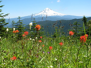
Meadows with great views of Mt. Hood
by sagamihara_hiker

 Likely In-Season! 
For a hike so close to Portland, it doesn't get the use that many others do. In 2005 the original McIntyre Trailhead was closed due to too much vandalism and misuse by OHV. Fortunately now there is a new trailhead accessible by car and just over an hour away from the Portland metro area. The trail starts off on a wide, old road which climbs up to meet the McIntyre trail. Once you reach this trail, turn right. At just 0.8 miles, you reach the first view point of Mt. Hood. Time it right (usually late June or early July) and you'll see Rhodendrums here. Contine on the trail here as it climbs to McIntyre Ridge. The last section is a little steep, but the payoff comes later. A little further down the trail, you reach the first meadow. Look for the flagging as you enter and exit the meadow. Continue on to the second meadow which is a sprawling meadow of bear grass. From here continue on to the third meadow (roughly 2.2 miles in) where the flowers and view are even more spectacular. In addition, there is a nice bench here to enjoy the view. The bench is dedicated to two hikers who frequented the area. It makes for a great a lunch spot, Mt. Hood rising right in front of you. For those with extra energy, you can continue on to Wildcat Mountain. A lookout tower was here but is no longer and trees now all but obscure the view. When you're done soaking in the views, return the way you came.

2010-07-11 sagamihara_hiker


    Check out the Official Route and Triplog.
    Leave No Trace and +Add a Triplog after your hike to support this local community.
    WARNING! Hiking and outdoor related sports can be dangerous. Be responsible and prepare for the trip. Study the area you are entering and plan accordingly. Dress for the current and unexpected weather changes. Take plenty of water. Never go alone. Make an itinerary with your plan(s), route(s), destination(s) and expected return time. Give your itinerary to trusted family and/or friends.

     Permit $$
    None

    Mount Hood Forest
    more info


     Directions
    or
     Road
    FR / Dirt Road / Gravel - Car Okay

    To hike
    Drive 30 miles east of Portland on Highway 26 to Firwood Road, located at Shorty's Corner, about two miles east of Sandy. Turn right onto Firwood, and continue a short distance before following Firwood right at a 3-way stop, then through several turns until reaching Wildcat Mountain Road at a 4-way stop, 3.4 miles from Highway 26.

    From the Firwood Road junction, turn left onto Wildcat Mountain Road (Forest Road 36) and follow this paved, two-lane road for 8.9 miles to the Mount Hood National Forest Boundary, where the road narrows to one lane with turnouts, and becomes Road 3626. Drive carefully here - sight distances are poor due to overgrown shoulders in many sections. Stay straight (uphill) at 9.4 miles, where the paved spur to the Wildcat Quarry and the Douglas Trail head to downhill and to the right.

    From this junction, continue another 3.5 miles on Road 3626 to the end of pavement, then watch for Forest Road 108, on the right, just a tenth of a mile from the end of the paved road. Turn onto Road 108, and continue the final two-tenths of a mile to the end of this gravel spur, where there is plenty of room to park on the shoulder.
    page created by sagamihara_hiker on Jul 11 2010 8:47 pm
     90+° 8am - 6pm kills
    helpcorrectionissue

    end of page marker