Route Editor

| Guide | ♦ | 1 Triplog | 0 Topics |
details | drive | no permit | forecast | route |
stats |
photos | triplog | topics | location |
| 30 | 1 | 0 |
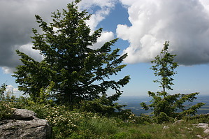
Great Hike in Eastern Washington by JimmyLyding The hike that is described here is widely regarded as the flagship hike in the park. It is frequently referred to as the "Three Peaks Loop," and is described as such in the popular book "100 Hikes in the Inland Northwest: Eastern Washington, Northern Rockies, Wallowas" by Rich Landers.
The first trail is #110, and it quickly climbs away from the trailhead with a mix of steep uphill and flatter segments. The forest here is a good example of the Columbian forest ecotype with mixed stands of Douglas fir, grand fir, ponderosa pine, Western redcedar, Western hemlock and larches under which extensive carpets of ferns and shrubbery dominate. The ponderosa pine in this region do not form the monolithic stands that we are used to seeing here in Arizona, but are only one of many species of conifer. This portion of the trail goes up the Burping Brook drainage before eventually crossing that creek at a picnic area. There is a 4-way junction here, but you want to remain on trail #110, and the signage is superb. The extensive signage in the park features color contour maps with outlined trails and "You Are Here" indicators. The trail continues uphill along gentle switchbacks as the forest opens up a bit. Long distance views are still hard to come by as the trail eventually makes its way to a yurt-like toilet at Mount Kit Carson Loop Road. This area evidently has seen some fire damage, and I guesstimate it probably occurred about 10-15 years ago. Go east on this road about 25 yards, then take trail #115 to the southwest for about 50 yards until its junction with trail #170 which heads west and will take you to the flattish summit of Mount Kit Carson. We saw some very friendly chipmunks here who tried to prey upon our snacks. Continue north on trail #170 to its junction with trail #130 and the summit of Day Mountain. The actual summit of Day Mountain is more of a ridge, and continuing down the trail for another 1/2 mile reveals an excellent spot with large rocks and incredible views of the Spokane River Valley, the Palouse, and the extensive mountains to the west and northwest. We continued down the switchbacks of trail #130 until it reconnected with the Mount Kit Carson loop road. We followed the road back up past the spot where we initially hit it to the top of Beauty Mountain and the CCC cabin. The trails here get very confusing with lots of intersecting roads, trails, and unofficial paths. Go east from the back side of the CCC cabin along a wide trail about 300 yards until its junction with trail #135. 135 can also be accessed from the Mount Kit Carson loop road just west of one of those helpful trail signs as well. This is the way to the summit of Mount Spokane. Trail #135 was somewhat of a mess when we did it due to mud, but the views are stunning. Mount Kit Carson and Day Mountain loom in the near distance with the Palouse and the city of Spokane further out. This area also looks to have suffered fire damage, but there are still a lot of large trees. This trail finally reaches road at the summit very near the Vista House which is used by the ski patrol of the ski area. The views from here are incredible. Lake Coeur d'Alene and Lake Pend Oreille in Idaho are in view from here as are the nearby high mountains in southern British Columbia. There is a nice viewpoint from the south side of the summit near the electronic towers as well. Head back down trail #135 back to trail #130 then over to Bald Knob campground @ Mount Spokane Park Drive. Cross the road and continue along 130 until heading south on 130a about 1/2 mile down from the road. This segment is relatively open forest along a nice drainage. You will run into the Snowmobile Trailhead, and from there take trail #120 downhill back towards your original trailhead. This trail has a noticeable downhill grade, and also goes through a very dense Columbian forest above a creek that flows far below. The ferns here are in abundance. Eventually you will reach trail 120b after 2 miles, and that will take you back to the trailhead. Check out the Official Route and Triplog. Leave No Trace and +Add a Triplog after your hike to support this local community. | |||||||||||||||||||||||||||||||||||||||||||||||||||||||||||||||||||||||||||||||||||||||||