Route Editor

| Guide | ♦ | 14 Triplogs | 0 Topics |
details | drive | no permit | forecast | 🔥 route |
stats |
photos | triplogs | topics | location |
| 129 | 14 | 0 |
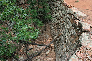
Old Road with Historic Rock Retaining Walls by JimmyLyding   There are two possible trailheads to begin this hike from its southern end. The Strawberry trailhead which is located 1/4 mile west of SR 87 milepost 270 on the south side provides the most parking, but there is also a small parking pullout at the beginning of this hike about 100 feet west of the same milepost on the north side of the highway. There are two possible trailheads to begin this hike from its southern end. The Strawberry trailhead which is located 1/4 mile west of SR 87 milepost 270 on the south side provides the most parking, but there is also a small parking pullout at the beginning of this hike about 100 feet west of the same milepost on the north side of the highway.This hike follows an old jeep trail up from SR 87 to the north. There is a fork at the beginning, and you want to veer to the right. There is another apparent fork about 200 feet up from there where the trail intersects a power line. Go left here in a northeasterly direction rather than following the power line. The trail here is fairly steep and rocky.
The portion of this trail that travels up the Fuller Spring drainage is marked by well-constructed rock walls that support the path as it traverses the various drainages coming off of the Mogollon Rim. The trail eventually tops out on the Mogollon Rim, and it's not a dramatic climax due to the Rim's gradual slope here. The trail has been fairly exposed to this point other than the portions when it crosses the rock-walled drainages, but it's now very exposed in chaparral vegetation. The official name of this trail changes from FR 608T to FR 608, and you can follow it to SR 87. To continue to SR 87 follow FR 608 to FR 9367R. Go right (east) at this junction for a few hundred feet before turning left (north) to continue along FR 608. Check out the Official Route and Triplogs. Leave No Trace and +Add a Triplog after your hike to support this local community. | ||||||||||||||||||||||||||||||||||||||||||||||||||||||||||||||||||||||||||||||||||||||||||||||||||||||||||||||||||||||||||||||||||||||||||||||||||||||||||||||||||||||||||||||||||||||||||||||||||||||||||||