 Route Editor

| Guide | ♦ | 22 Triplogs | 1 Topic |
details | drive | no permit | forecast | 🔥 route |
stats |
photos | triplogs | topic | location |
| 205 | 22 | 1 |
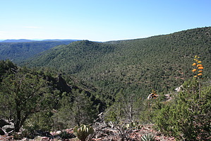
Scenic Views of Pine and Milk Ranch Point by JimmyLyding   Please note that my GPS route, elevation gain, and AEG are from south to north while the hike description is from north to south from the Strawberry trailhead. Please note that my GPS route, elevation gain, and AEG are from south to north while the hike description is from north to south from the Strawberry trailhead.The hamlet of Strawberry is named so because the residents who settled the area in the late 19th Century found an abundance of strawberries in the area.
The trail then leaves the drainage and follows the eastern contours of Strawberry Mountain about 1/2 mile from the trailhead. The trail then assumes its normal character with alternating views to the east of the town of Pine and the Milk Ranch Point portion of the Mogollon Rim and the tall timber in the small drainages that flow east from Strawberry Mountain. These timbered areas feature Ponderosa Pine, Alligator Juniper, Gambel Oak, Arizona Cypress, and small-ish New Mexico Locust. The trail continues along the east side of Strawberry Mountain roughly following the 5800' contour until descends to Cottonwood Spring before gently ascending the southeastern part of Strawberry Mountain. From here it quickly descends via a few switchbacks to Hardscrabble Road/FR 428. The Walnut Trail #251 continues to the south of this road. Check out the Official Route and Triplogs. Leave No Trace and +Add a Triplog after your hike to support this local community. One-Way Notice This hike is listed as One-Way. When hiking several trails on a single "hike", log it with a generic name that describes the hike. Then link the trails traveled, check out the example. | |||||||||||||||||||||||||||||||||||||||||||||||||||||||||||||||||||||||||||||||||||||||||||||||||||||||||||||||||||||||||||||||||||||||||||||||||||||||||||||||||||||||||||||||||||||||||||||||


