Route Editor

| Guide | ♦ | 20 Triplogs | 2 Topics |
details | drive | no permit | forecast | route |
stats |
photos | triplogs | topics | location |
| 138 | 20 | 2 |
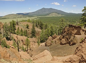
Hoodoos anyone? by fotogirl53  Wild Bill Hill is a cinder cone-shaped like a cloverleaf overlooking Government Prairie. Between the northern summit and the western summit, the side of the volcano has eroded, leaving interesting and picturesque hoodoos. Wild Bill Hill is a cinder cone-shaped like a cloverleaf overlooking Government Prairie. Between the northern summit and the western summit, the side of the volcano has eroded, leaving interesting and picturesque hoodoos.The roads to Wild Bill Hill range from graded to rough, smooth to rutted, and during monsoon season, dry to deep tracks of water and mud. A high-clearance vehicle is recommended for the last 3 miles. You might need four-wheel drive if the area has received a lot of moisture.
When you reach the top, find the faint trail to the east, which leads to the top of the eastern knob. This bald summit is perfect for a 360-degree panoramic view of Government Prairie, the San Francisco Peaks, and Kendrick Mt. There are two markers for those of you who "collect" them. Wildflowers and cacti can be found up there, too. Go back down the trail to the saddle, and pick up the trail leading to the west, toward the saddle between the western and northern summits. In just a couple hundred yards, surprise! The side of the volcano has eroded, leaving a canyon full of hoodoos. The trail to the right goes up the northern slope of the summit, where there are good views of the hoodoos. The erosion has resulted in interesting growth of Ponderosa and limber pines. Unfortunately, there isn't a formal trail to the top of the summit. Back down the trail to the saddle, then continue along a spine that goes out on the rim of the hoodoos. Be very careful as the ground is made up of small gravel that is very slick on the steep slopes. If you want to summit the western knob, it is very steep from the hoodoos. You might want to backtrack to attack it from the first saddle. The summit is listed at 8189 feet. However, from the hoodoos, the trail continues south to a smaller hoodoo area, then around the hill back to the trailhead. The trail takes you through s beautiful stand of big, old-growth fir trees. As you descend in elevation, the trees thin out to grassland. I lost the trail but easily continued around the hill until my truck came into sight. Check out the Official Route and Triplogs. Leave No Trace and +Add a Triplog after your hike to support this local community. | ||||||||||||||||||||||||||||||||||||||||||||||||||||||||||||||||||||||||||||||||||||||||||||||||||||||||||||||||||||||||||||||||||||||||||||||||||||||||||||||||||||||||||||||||||||||