 Route Editor

| Guide | ♦ | 3 Triplogs | 0 Topics |
details | drive | permit | forecast | map |
stats |
photos | triplogs | topics | location |
| 11 | 3 | 0 |
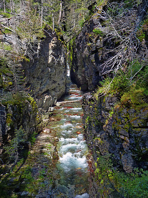
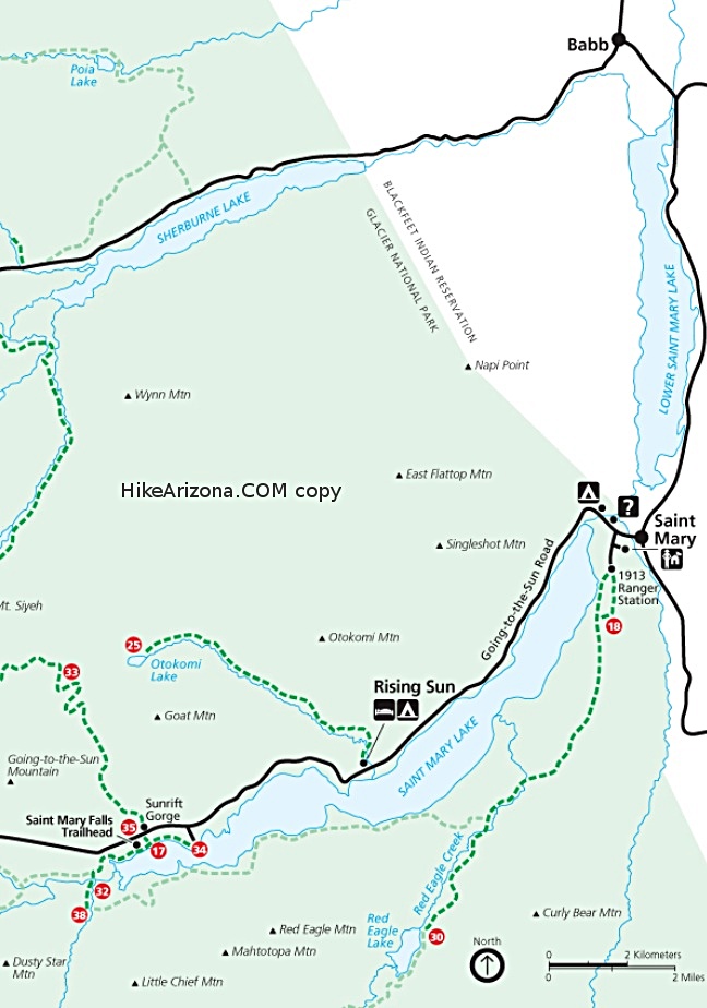
I found two stories about Sunrift Gorge's formation: 1) It was formed when a small stream cut through a natural break in the rock. The gorge is fed by runoff from Sexton Glacier on GTTS Mtn. Sunrift Gorge is a straight steep canyon cut through the bedrock just 200 feet off the main road. Baring Creek comes down an extremely narrow gorge. Be sure to walk to the far side of the viewing area for full appreciation of the gorge. It is quite long and deepm the Gorge that is -- not much sun gets in there. 2) Apparently after a section of ice melted, the massive block of rock that sat beneath the hillside to the south, broke away and moved a few feet downhill. The creek then re-routed and found its new course through the new, narrow, straight slot. (The steep approach to the Siyeh Pass Area starts here as well.)
Follow the trail along Baring Creek's edge viewing a few little waterfalls/cascades as you make your way to Baring Falls. A 0.3 mile (one way) trail leads to Baring Falls Lat/Long:48.67773, -113.59692. A 150 foot elevation drop. It is an easy stroll through fir and pine forest with lots of wildflowers in the sunny areas. Cross a foot log bridge to reach the base of the falls at 4630 feet. Baring Falls is an impressive cascade that drops about 30-40 feet over a cliff onto a smooth, red wall of Precambrian mudstone then rushes for about fifty yards where it empties into St Mary's lake. Hikers may continue from here about 1.7 miles to St Mary's Falls and another .8 miles to Virginia Falls.
Check out the Triplogs. Leave No Trace and +Add a Triplog after your hike to support this local community. One-Way Notice This hike is listed as One-Way. When hiking several trails on a single "hike", log it with a generic name that describes the hike. Then link the trails traveled, check out the example. | ||||||||||||||||||||||||||||||||||||||||||||||||||||||||||||||||||||||||||


