username
X
password
register
for free!
help


Gold Hill Loop, NM

Guide 5 Triplogs  0 Topics
  5 of 5  
Fav
Wish
0
details
drive
no permit
forecast
route  
stats
photos
triplogs
topics
location
39 5 0
Statistics
tap row or icons for details
Difficulty 5 of 5
Distance Round Trip 10.3 miles
Trailhead Elevation 9,438 feet
Elevation Gain 3,254 feet
Accumulated Gain 3,442 feet
Kokopelli Seeds 27.51
 Interest Historic, Perennial Creek & Peak
unreported if dogs are allowed
editedit > ops > dogs to adjust
feature photo
Photos Viewed All MineFollowing
Inaugural Calculation on Button Tap!
19  2017-09-02
Gold Hill Long Canyon Loop
BiFrost
24  2010-08-15 gpsjoe
15  2010-08-15 Grasshopper
Author
author avatar Guides 16,832
Routes 17,472
Photos 24
Trips 1 map ( 6 miles )
Age Male Gender
Location HAZ, TrailDEX
Associated Areas
list map done
North Central Region
Historical Weather
Trailhead Forecast
Radar Map
Expand Map
Preferred Jul, Jun, Aug, Sep
Sun  6:14am - 5:18pm
Official Route & 1 Rt
 
2 Alternative


remove free decal offer

 
Expand MapOverview
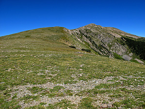
This scenic and diverse partial loop to one of the Wheeler Peak Wilderness high viewpoints qualifies as more of a strenuous hike to a mountain peak than to the top of a hill. Views from the two top high points at 12,711 feet rivals those of nearby Wheeler Peak (New Mexico's highest).


    Check out the Official Route and Triplogs.

    Note
    This is a difficult hike. Arrive fit and prepared or this could get ugly.
    Leave No Trace and +Add a Triplog after your hike to support this local community.
    WARNING! Hiking and outdoor related sports can be dangerous. Be responsible and prepare for the trip. Study the area you are entering and plan accordingly. Dress for the current and unexpected weather changes. Take plenty of water. Never go alone. Make an itinerary with your plan(s), route(s), destination(s) and expected return time. Give your itinerary to trusted family and/or friends.

     Permit $$
    None


     Directions
    or
     Road
    Paved - Car Okay

    To hike
    From the center of Taos, NM: Drive 4 miles north on NM 64 to the junction of NM 150 and NM64. Turn right onto NM150 and drive 15 winding road miles up to the upper parking lot of Taos Ski village. After the large welcoming sign on the left, turn into the large upper parking lot and follow it approx .3mls past this upper lot area to the Trail Head parking and Trail#90 start on the left side, just behind the wilderness information sign. (Also see posted GPS Driving Route from the intersection of NM 64/150 to TH Parking and Trail Start);
    page created by Grasshopper on Aug 30 2010 9:02 am
    helpcorrectionissue

    end of page marker