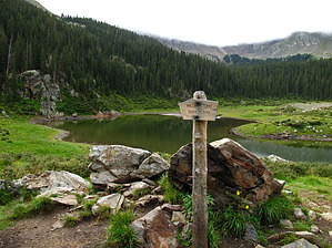
Overview: Starting from the upper TH, the less than 2.5 mile one way Williams Lake Trail#62 hike is a popular midsummer stroll and/or an excellent winter snowshoe trip enjoyed by all ages. The 965 foot climb to the lake over a gentle pass at 11.1k feet greets you with a deep basin cirque lake completely surrounded by a jagged ring of peaks. Although the summit is not visible from the lake, Wheeler Peak- the state's highest point at 13,161 ft- forms the eastern rim of the Williams Lake cirque and offers an "unofficial" and popular use route from the lake up to the summit of Wheeler Peak (Note: this "use route" starts from the beginning east side of the lake at way point N36.55775 W105.42998).
WARNING! Hiking and outdoor related sports can be dangerous. Be responsible and prepare for the trip. Study the area you are entering and plan accordingly. Dress for the current and unexpected weather changes. Take plenty of water. Never go alone. Make an itinerary with your plan(s), route(s), destination(s) and expected return time. Give your itinerary to trusted family and/or friends.
Permit $$
None
Directions
Road
FR / Jeep Road - Car possible when dry
To hike From the center of Taos, NM: Drive 4 miles north on NM 64 to the junction of NM 150 and NM64. Turn right onto NM150 and drive 15 winding road miles up to the upper parking lot of Taos Ski village. After the large welcoming sign on the left, turn into the large upper parking lot and follow it approx .3mls past this upper lot area to the Trail Head parking and Trail#90 start on the left side, just behind the wilderness information sign (Note: you are now at way point N36.59668 W105.44969); From this way point location "drive/follow the posted driving route" for 1.9 miles to end at the upper TH Parking and Trail Start for Williams Lake TR#62 (at way point N36.57938 W105.44003);
page created by Grasshopper on Aug 30 2010 3:56 pm
 Route Editor