 Route Editor

| Guide | ♦ | 39 Triplogs | 1 Topic |
details | drive | no permit | forecast | 🔥 route |
stats |
photos | triplogs | topic | location |
| 0 | 39 | 1 |
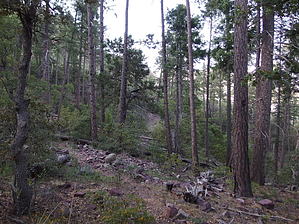
A short cut around the east side of Mazatzal peak by Wild Bill   Note NoteThis is the exact same trail as the Y Bar Basin Trail. History This trail is often referred to as the Y bar tank trail by the local Cowboys of the area, I always enjoy the views looking east toward the Sierra Ancha Mountain the Mogollon Rim to the north, this trail was a known trail and often used By early pioneers like David Gowan due to the abundant wild life in the area Hike The first there 2.75 miles there are switchbacks and some really neat washes as you climb to about 5500 ft and come to Cactus ridge, you cut southwest up the valley to heading towards Y Bar tanks at the 3.6 mile point your at about 6300 ft.where you then drop back down to around 5800 ft. until the 4.25 mile point as you arrive at the Y-Bar tanks.this is a great overnight camping spot if so inclined, there is a fork in the trail so if you want to go around to the back side of Mazatzal peak (a short-cut) you can head west ,or you can head south up to the Mazatzal Divide trail to the south as well. I went west around to the back side of the Mazatzal's. I got to see an awesome sunset over Horseshoe Lake some 13 miles away, at the turn around point I was at around 6550 ft. after walking around 5.4 miles. Another interest thing with this trail is that your really close to the peak if your interested in conquering the Mazatzal Peak at 7903 ft. instead of going around from the Barnhardt trail to the mazatzal Divide way north of the turn around point. Check out the Official Route and Triplogs. Leave No Trace and +Add a Triplog after your hike to support this local community. One-Way Notice This hike is listed as One-Way. When hiking several trails on a single "hike", log it with a generic name that describes the hike. Then link the trails traveled, check out the example. | ||||||||||||||||||||||||||||||||||||||||||||||||||||||||||||||||||||||||||||||||||||||||||||||||||||||||||||||||||||||||||||||||||||||||||||||||||||||||||||||||||||||||||||||||||||||||||||||||||||||||||||||||||||||


