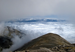
Overview: This Colorado 14er at 14,229 feet above sea level and 4.5 miles one way with a total one way elevation gain of ~4500 feet does not have much of a trail to follow on the final pitch up to the summit. It does have some mighty fine near and long distance views to enjoy at the summit top!
Also, it should be noted that this is the standard hiking route to summit Mount Shavano. Strong hikers with an early start might want to continue on to Mount Tabeguache (14,155 feet elevation), .90 miles past Mount Shavano. This would be a hike over rugged ridge line with some Class 2, adding ~1.8 total miles and 1,100 feet AEG to the trip.
WARNING! Hiking and outdoor related sports can be dangerous. Be responsible and prepare for the trip. Study the area you are entering and plan accordingly. Dress for the current and unexpected weather changes. Take plenty of water. Never go alone. Make an itinerary with your plan(s), route(s), destination(s) and expected return time. Give your itinerary to trusted family and/or friends.
Permit $$
None
Directions
Road
FR / Jeep Road - Car possible when dry
To hike Approximately twenty-one miles south of Buena Vista, CO, on Hwy 285, at the intersection of Colorado Hwy 285/CO 140, take CO140 west to CO 250 north to a left at the "Y" onto CO 252 then 252 to another small junction just past a cattle guard 2.9mls in; continue on CO 252 for an additional 0.2mls to Jennings Creek TH- Mount Shavano TR Start (at way point N38.59688 W106.19701); For your convenience the "GPS Driving Directions" to this TH is attached to the hike description;
page created by Grasshopper on Sep 04 2010 11:30 pm
 Route Editor